You are here: Home > Network List > TA - USArray Transportable Network (new EarthScope stations) Stations List
> Station G03D McMinnville, OR, USA > Earthquake Result Viewer
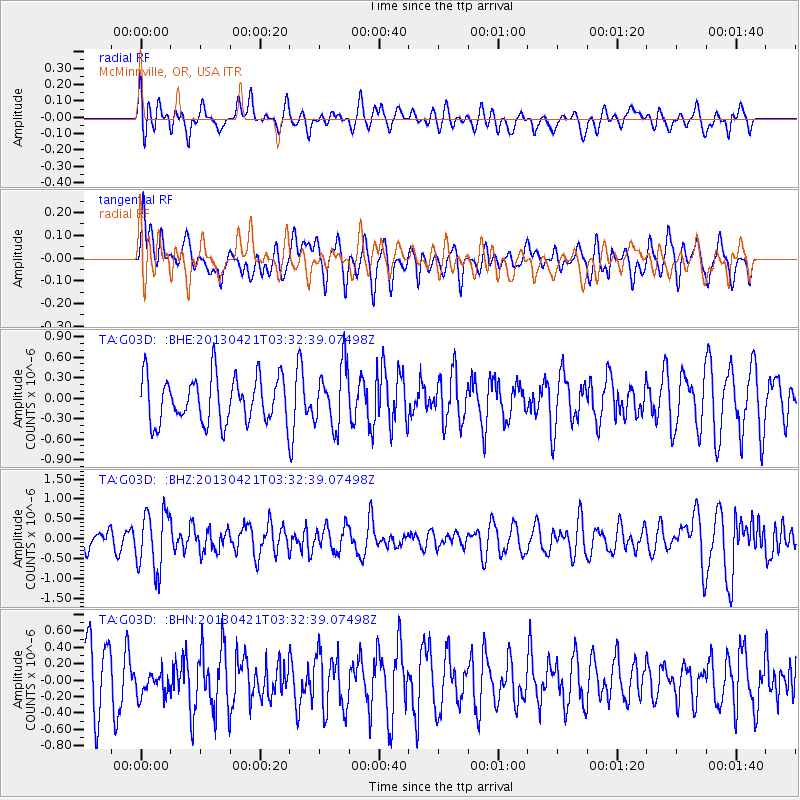
G03D McMinnville, OR, USA - Earthquake Result Viewer
*The percent match for this event was below the threshold and hence no stack was calculated.
| Earthquake location: |
Southeast Of Honshu, Japan |
| Earthquake latitude/longitude: |
29.9/138.9 |
| Earthquake time(UTC): |
2013/04/21 (111) 03:22:16 GMT |
| Earthquake Depth: |
422 km |
| Earthquake Magnitude: |
6.1 MW, 5.7 MB, 6.1 MW |
| Earthquake Catalog/Contributor: |
NEIC PDE/NEIC PDE-W |
|
| Network: |
TA USArray Transportable Network (new EarthScope stations) |
| Station: |
G03D McMinnville, OR, USA |
| Lat/Lon: |
45.21 N/123.26 W |
| Elevation: |
222 m |
|
| Distance: |
74.5 deg |
| Az: |
46.611 deg |
| Baz: |
296.822 deg |
| Ray Param: |
$rayparam |
*The percent match for this event was below the threshold and hence was not used in the summary stack. |
|
| Radial Match: |
44.73919 % |
| Radial Bump: |
400 |
| Transverse Match: |
43.799927 % |
| Transverse Bump: |
400 |
| SOD ConfigId: |
512894 |
| Insert Time: |
2013-09-13 15:59:04.034 +0000 |
| GWidth: |
2.5 |
| Max Bumps: |
400 |
| Tol: |
0.001 |
|
Signal To Noise
| Channel | StoN | STA | LTA |
| TA:G03D: :BHZ:20130421T03:32:39.07498Z | 2.85263 | 7.350728E-7 | 2.5768247E-7 |
| TA:G03D: :BHN:20130421T03:32:39.07498Z | 0.42154574 | 1.451903E-7 | 3.4442357E-7 |
| TA:G03D: :BHE:20130421T03:32:39.07498Z | 1.3224185 | 4.4536804E-7 | 3.36783E-7 |
| Arrivals |
| Ps | |
| PpPs | |
| PsPs/PpSs | |


