You are here: Home > Network List > TA - USArray Transportable Network (new EarthScope stations) Stations List
> Station G45A Suttons Bay, MI, USA > Earthquake Result Viewer
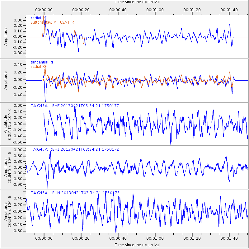
G45A Suttons Bay, MI, USA - Earthquake Result Viewer
*The percent match for this event was below the threshold and hence no stack was calculated.
| Earthquake location: |
Southeast Of Honshu, Japan |
| Earthquake latitude/longitude: |
29.9/138.9 |
| Earthquake time(UTC): |
2013/04/21 (111) 03:22:16 GMT |
| Earthquake Depth: |
422 km |
| Earthquake Magnitude: |
6.1 MW, 5.7 MB, 6.1 MW |
| Earthquake Catalog/Contributor: |
NEIC PDE/NEIC PDE-W |
|
| Network: |
TA USArray Transportable Network (new EarthScope stations) |
| Station: |
G45A Suttons Bay, MI, USA |
| Lat/Lon: |
45.04 N/85.66 W |
| Elevation: |
284 m |
|
| Distance: |
95.1 deg |
| Az: |
29.952 deg |
| Baz: |
322.316 deg |
| Ray Param: |
$rayparam |
*The percent match for this event was below the threshold and hence was not used in the summary stack. |
|
| Radial Match: |
41.378014 % |
| Radial Bump: |
400 |
| Transverse Match: |
48.36645 % |
| Transverse Bump: |
400 |
| SOD ConfigId: |
512894 |
| Insert Time: |
2013-09-13 16:00:34.635 +0000 |
| GWidth: |
2.5 |
| Max Bumps: |
400 |
| Tol: |
0.001 |
|
Signal To Noise
| Channel | StoN | STA | LTA |
| TA:G45A: :BHZ:20130421T03:34:21.175017Z | 2.8559709 | 4.465507E-7 | 1.5635689E-7 |
| TA:G45A: :BHN:20130421T03:34:21.175017Z | 0.9255555 | 2.2035594E-7 | 2.3807965E-7 |
| TA:G45A: :BHE:20130421T03:34:21.175017Z | 0.6395407 | 1.6891212E-7 | 2.6411473E-7 |
| Arrivals |
| Ps | |
| PpPs | |
| PsPs/PpSs | |


