You are here: Home > Network List > TA - USArray Transportable Network (new EarthScope stations) Stations List
> Station T25A Trinidad, CO, USA > Earthquake Result Viewer
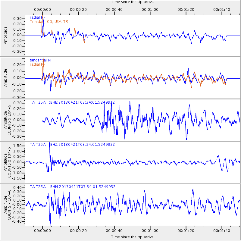
T25A Trinidad, CO, USA - Earthquake Result Viewer
*The percent match for this event was below the threshold and hence no stack was calculated.
| Earthquake location: |
Southeast Of Honshu, Japan |
| Earthquake latitude/longitude: |
29.9/138.9 |
| Earthquake time(UTC): |
2013/04/21 (111) 03:22:16 GMT |
| Earthquake Depth: |
422 km |
| Earthquake Magnitude: |
6.1 MW, 5.7 MB, 6.1 MW |
| Earthquake Catalog/Contributor: |
NEIC PDE/NEIC PDE-W |
|
| Network: |
TA USArray Transportable Network (new EarthScope stations) |
| Station: |
T25A Trinidad, CO, USA |
| Lat/Lon: |
37.14 N/104.41 W |
| Elevation: |
2017 m |
|
| Distance: |
90.8 deg |
| Az: |
45.558 deg |
| Baz: |
309.145 deg |
| Ray Param: |
$rayparam |
*The percent match for this event was below the threshold and hence was not used in the summary stack. |
|
| Radial Match: |
48.873314 % |
| Radial Bump: |
387 |
| Transverse Match: |
53.04652 % |
| Transverse Bump: |
391 |
| SOD ConfigId: |
512894 |
| Insert Time: |
2013-09-13 16:19:49.407 +0000 |
| GWidth: |
2.5 |
| Max Bumps: |
400 |
| Tol: |
0.001 |
|
Signal To Noise
| Channel | StoN | STA | LTA |
| TA:T25A: :BHZ:20130421T03:34:01.524993Z | 6.389637 | 5.389553E-7 | 8.434834E-8 |
| TA:T25A: :BHN:20130421T03:34:01.524993Z | 1.9140275 | 1.6275506E-7 | 8.5032774E-8 |
| TA:T25A: :BHE:20130421T03:34:01.524993Z | 2.001681 | 1.025389E-7 | 5.122639E-8 |
| Arrivals |
| Ps | |
| PpPs | |
| PsPs/PpSs | |


