You are here: Home > Network List > US - United States National Seismic Network Stations List
> Station AHID Auburn Hatchery, Idaho, USA > Earthquake Result Viewer
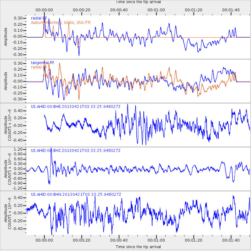
AHID Auburn Hatchery, Idaho, USA - Earthquake Result Viewer
*The percent match for this event was below the threshold and hence no stack was calculated.
| Earthquake location: |
Southeast Of Honshu, Japan |
| Earthquake latitude/longitude: |
29.9/138.9 |
| Earthquake time(UTC): |
2013/04/21 (111) 03:22:16 GMT |
| Earthquake Depth: |
422 km |
| Earthquake Magnitude: |
6.1 MW, 5.7 MB, 6.1 MW |
| Earthquake Catalog/Contributor: |
NEIC PDE/NEIC PDE-W |
|
| Network: |
US United States National Seismic Network |
| Station: |
AHID Auburn Hatchery, Idaho, USA |
| Lat/Lon: |
42.77 N/111.10 W |
| Elevation: |
1960 m |
|
| Distance: |
83.3 deg |
| Az: |
44.166 deg |
| Baz: |
304.786 deg |
| Ray Param: |
$rayparam |
*The percent match for this event was below the threshold and hence was not used in the summary stack. |
|
| Radial Match: |
47.76873 % |
| Radial Bump: |
400 |
| Transverse Match: |
47.84591 % |
| Transverse Bump: |
400 |
| SOD ConfigId: |
512894 |
| Insert Time: |
2013-09-13 16:22:38.535 +0000 |
| GWidth: |
2.5 |
| Max Bumps: |
400 |
| Tol: |
0.001 |
|
Signal To Noise
| Channel | StoN | STA | LTA |
| US:AHID:00:BHZ:20130421T03:33:25.948027Z | 9.366101 | 5.206503E-7 | 5.55888E-8 |
| US:AHID:00:BHN:20130421T03:33:25.948027Z | 1.4301089 | 1.899371E-7 | 1.3281303E-7 |
| US:AHID:00:BHE:20130421T03:33:25.948027Z | 2.1378841 | 2.2067026E-7 | 1.03218994E-7 |
| Arrivals |
| Ps | |
| PpPs | |
| PsPs/PpSs | |


