You are here: Home > Network List > US - United States National Seismic Network Stations List
> Station HAWA Hanford, Washington, USA > Earthquake Result Viewer
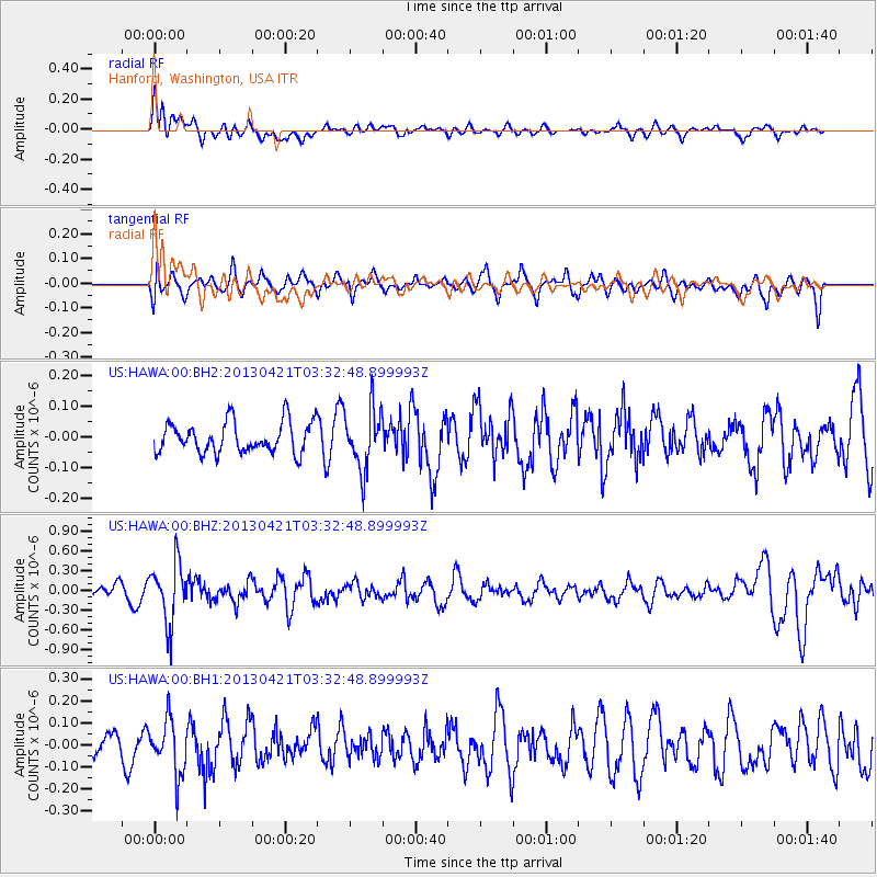
HAWA Hanford, Washington, USA - Earthquake Result Viewer
*The percent match for this event was below the threshold and hence no stack was calculated.
| Earthquake location: |
Southeast Of Honshu, Japan |
| Earthquake latitude/longitude: |
29.9/138.9 |
| Earthquake time(UTC): |
2013/04/21 (111) 03:22:16 GMT |
| Earthquake Depth: |
422 km |
| Earthquake Magnitude: |
6.1 MW, 5.7 MB, 6.1 MW |
| Earthquake Catalog/Contributor: |
NEIC PDE/NEIC PDE-W |
|
| Network: |
US United States National Seismic Network |
| Station: |
HAWA Hanford, Washington, USA |
| Lat/Lon: |
46.39 N/119.53 W |
| Elevation: |
364 m |
|
| Distance: |
76.2 deg |
| Az: |
44.272 deg |
| Baz: |
298.898 deg |
| Ray Param: |
$rayparam |
*The percent match for this event was below the threshold and hence was not used in the summary stack. |
|
| Radial Match: |
62.180016 % |
| Radial Bump: |
400 |
| Transverse Match: |
45.881264 % |
| Transverse Bump: |
400 |
| SOD ConfigId: |
512894 |
| Insert Time: |
2013-09-13 16:25:16.325 +0000 |
| GWidth: |
2.5 |
| Max Bumps: |
400 |
| Tol: |
0.001 |
|
Signal To Noise
| Channel | StoN | STA | LTA |
| US:HAWA:00:BHZ:20130421T03:32:48.899993Z | 5.3550487 | 4.4752815E-7 | 8.357126E-8 |
| US:HAWA:00:BH1:20130421T03:32:48.899993Z | 1.8836415 | 1.2306468E-7 | 6.533339E-8 |
| US:HAWA:00:BH2:20130421T03:32:48.899993Z | 1.9789639 | 9.992769E-8 | 5.0494954E-8 |
| Arrivals |
| Ps | |
| PpPs | |
| PsPs/PpSs | |


