You are here: Home > Network List > UU - University of Utah Regional Network Stations List
> Station CCUT Cedar City, UT, USA > Earthquake Result Viewer
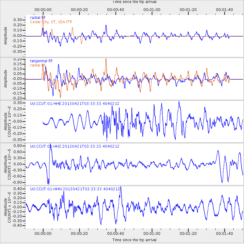
CCUT Cedar City, UT, USA - Earthquake Result Viewer
*The percent match for this event was below the threshold and hence no stack was calculated.
| Earthquake location: |
Southeast Of Honshu, Japan |
| Earthquake latitude/longitude: |
29.9/138.9 |
| Earthquake time(UTC): |
2013/04/21 (111) 03:22:16 GMT |
| Earthquake Depth: |
422 km |
| Earthquake Magnitude: |
6.1 MW, 5.7 MB, 6.1 MW |
| Earthquake Catalog/Contributor: |
NEIC PDE/NEIC PDE-W |
|
| Network: |
UU University of Utah Regional Network |
| Station: |
CCUT Cedar City, UT, USA |
| Lat/Lon: |
37.55 N/113.36 W |
| Elevation: |
2127 m |
|
| Distance: |
84.8 deg |
| Az: |
49.473 deg |
| Baz: |
303.884 deg |
| Ray Param: |
$rayparam |
*The percent match for this event was below the threshold and hence was not used in the summary stack. |
|
| Radial Match: |
56.327507 % |
| Radial Bump: |
400 |
| Transverse Match: |
64.03171 % |
| Transverse Bump: |
400 |
| SOD ConfigId: |
512894 |
| Insert Time: |
2013-09-13 16:29:46.575 +0000 |
| GWidth: |
2.5 |
| Max Bumps: |
400 |
| Tol: |
0.001 |
|
Signal To Noise
| Channel | StoN | STA | LTA |
| UU:CCUT:01:HHZ:20130421T03:33:33.404021Z | 5.386779 | 5.342389E-7 | 9.917594E-8 |
| UU:CCUT:01:HHN:20130421T03:33:33.404021Z | 1.2973777 | 9.470296E-8 | 7.299568E-8 |
| UU:CCUT:01:HHE:20130421T03:33:33.404021Z | 1.1255642 | 7.994068E-8 | 7.102277E-8 |
| Arrivals |
| Ps | |
| PpPs | |
| PsPs/PpSs | |


