You are here: Home > Network List > AZ - ANZA Regional Network Stations List
> Station SMER AZ.SMER > Earthquake Result Viewer
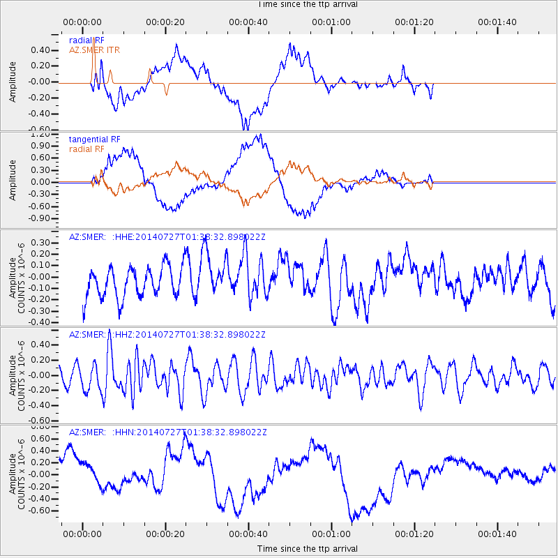
SMER AZ.SMER - Earthquake Result Viewer
*The percent match for this event was below the threshold and hence no stack was calculated.
| Earthquake location: |
Northern Mid-Atlantic Ridge |
| Earthquake latitude/longitude: |
23.8/-45.6 |
| Earthquake time(UTC): |
2014/07/27 (208) 01:28:38 GMT |
| Earthquake Depth: |
10 km |
| Earthquake Magnitude: |
5.6 MB, 6.0 MWB, 6.6 MI |
| Earthquake Catalog/Contributor: |
NEIC PDE/NEIC COMCAT |
|
| Network: |
AZ ANZA Regional Network |
| Station: |
SMER AZ.SMER |
| Lat/Lon: |
33.46 N/117.17 W |
| Elevation: |
355 m |
|
| Distance: |
62.4 deg |
| Az: |
296.575 deg |
| Baz: |
78.575 deg |
| Ray Param: |
$rayparam |
*The percent match for this event was below the threshold and hence was not used in the summary stack. |
|
| Radial Match: |
55.948368 % |
| Radial Bump: |
400 |
| Transverse Match: |
58.096382 % |
| Transverse Bump: |
400 |
| SOD ConfigId: |
3390531 |
| Insert Time: |
2019-04-13 01:20:24.733 +0000 |
| GWidth: |
2.5 |
| Max Bumps: |
400 |
| Tol: |
0.001 |
|
Signal To Noise
| Channel | StoN | STA | LTA |
| AZ:SMER: :HHZ:20140727T01:38:32.898022Z | 2.035136 | 1.7281782E-7 | 8.491708E-8 |
| AZ:SMER: :HHN:20140727T01:38:32.898022Z | 0.8744239 | 1.9415151E-7 | 2.2203362E-7 |
| AZ:SMER: :HHE:20140727T01:38:32.898022Z | 1.633576 | 2.1070265E-7 | 1.2898246E-7 |
| Arrivals |
| Ps | |
| PpPs | |
| PsPs/PpSs | |


