You are here: Home > Network List > AZ - ANZA Regional Network Stations List
> Station LVA2 AZ.LVA2 > Earthquake Result Viewer
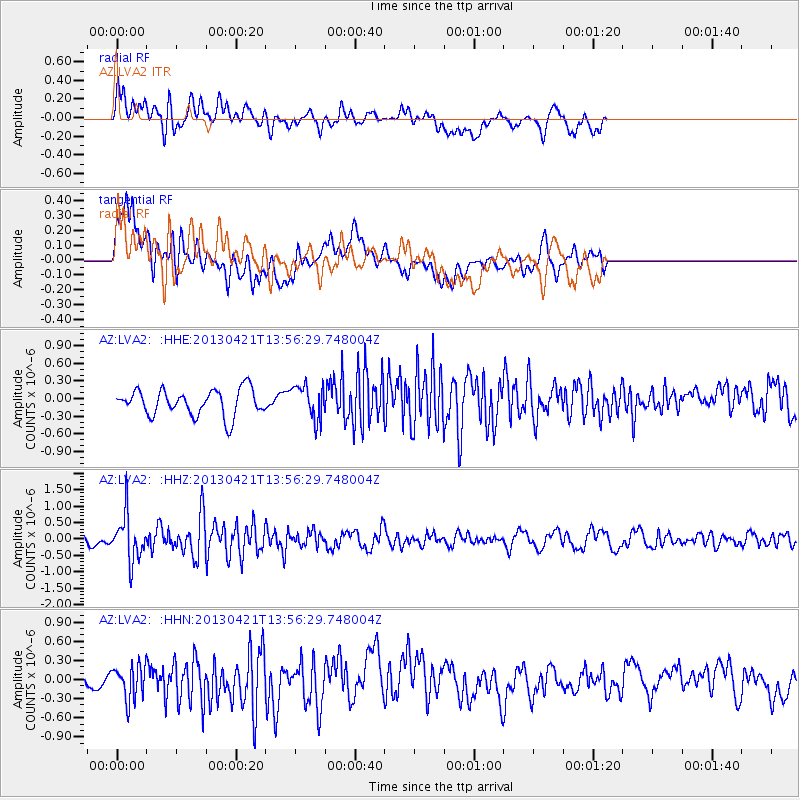
LVA2 AZ.LVA2 - Earthquake Result Viewer
*The percent match for this event was below the threshold and hence no stack was calculated.
| Earthquake location: |
Andreanof Islands, Aleutian Is. |
| Earthquake latitude/longitude: |
51.7/-178.2 |
| Earthquake time(UTC): |
2013/04/21 (111) 13:48:29 GMT |
| Earthquake Depth: |
44 km |
| Earthquake Magnitude: |
5.6 MW, 5.7 MW, 5.9 MB |
| Earthquake Catalog/Contributor: |
NEIC PDE/NEIC PDE-W |
|
| Network: |
AZ ANZA Regional Network |
| Station: |
LVA2 AZ.LVA2 |
| Lat/Lon: |
33.35 N/116.56 W |
| Elevation: |
1435 m |
|
| Distance: |
47.5 deg |
| Az: |
87.657 deg |
| Baz: |
311.968 deg |
| Ray Param: |
$rayparam |
*The percent match for this event was below the threshold and hence was not used in the summary stack. |
|
| Radial Match: |
64.06582 % |
| Radial Bump: |
400 |
| Transverse Match: |
59.17222 % |
| Transverse Bump: |
400 |
| SOD ConfigId: |
512894 |
| Insert Time: |
2013-09-13 16:50:53.323 +0000 |
| GWidth: |
2.5 |
| Max Bumps: |
400 |
| Tol: |
0.001 |
|
Signal To Noise
| Channel | StoN | STA | LTA |
| AZ:LVA2: :HHZ:20130421T13:56:29.748004Z | 3.3443658 | 6.823747E-7 | 2.0403712E-7 |
| AZ:LVA2: :HHN:20130421T13:56:29.748004Z | 1.4003898 | 2.6917687E-7 | 1.9221567E-7 |
| AZ:LVA2: :HHE:20130421T13:56:29.748004Z | 1.2883233 | 2.855635E-7 | 2.2165514E-7 |
| Arrivals |
| Ps | |
| PpPs | |
| PsPs/PpSs | |


