You are here: Home > Network List > IW - Intermountain West Stations List
> Station MOOW Moose Ponds, Wyoming, USA > Earthquake Result Viewer
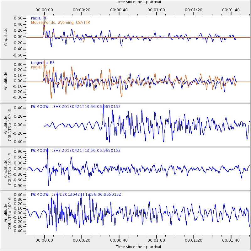
MOOW Moose Ponds, Wyoming, USA - Earthquake Result Viewer
*The percent match for this event was below the threshold and hence no stack was calculated.
| Earthquake location: |
Andreanof Islands, Aleutian Is. |
| Earthquake latitude/longitude: |
51.7/-178.2 |
| Earthquake time(UTC): |
2013/04/21 (111) 13:48:29 GMT |
| Earthquake Depth: |
44 km |
| Earthquake Magnitude: |
5.6 MW, 5.7 MW, 5.9 MB |
| Earthquake Catalog/Contributor: |
NEIC PDE/NEIC PDE-W |
|
| Network: |
IW Intermountain West |
| Station: |
MOOW Moose Ponds, Wyoming, USA |
| Lat/Lon: |
43.75 N/110.74 W |
| Elevation: |
2128 m |
|
| Distance: |
44.6 deg |
| Az: |
72.417 deg |
| Baz: |
304.985 deg |
| Ray Param: |
$rayparam |
*The percent match for this event was below the threshold and hence was not used in the summary stack. |
|
| Radial Match: |
69.92919 % |
| Radial Bump: |
400 |
| Transverse Match: |
67.056656 % |
| Transverse Bump: |
400 |
| SOD ConfigId: |
512894 |
| Insert Time: |
2013-09-13 17:04:57.181 +0000 |
| GWidth: |
2.5 |
| Max Bumps: |
400 |
| Tol: |
0.001 |
|
Signal To Noise
| Channel | StoN | STA | LTA |
| IW:MOOW: :BHZ:20130421T13:56:06.965015Z | 6.2686243 | 3.6743396E-7 | 5.8614766E-8 |
| IW:MOOW: :BHN:20130421T13:56:06.965015Z | 3.316741 | 1.5356025E-7 | 4.629853E-8 |
| IW:MOOW: :BHE:20130421T13:56:06.965015Z | 4.5792875 | 1.8644926E-7 | 4.071578E-8 |
| Arrivals |
| Ps | |
| PpPs | |
| PsPs/PpSs | |


