You are here: Home > Network List > TA - USArray Transportable Network (new EarthScope stations) Stations List
> Station Q59A Harwood, MD, USA > Earthquake Result Viewer
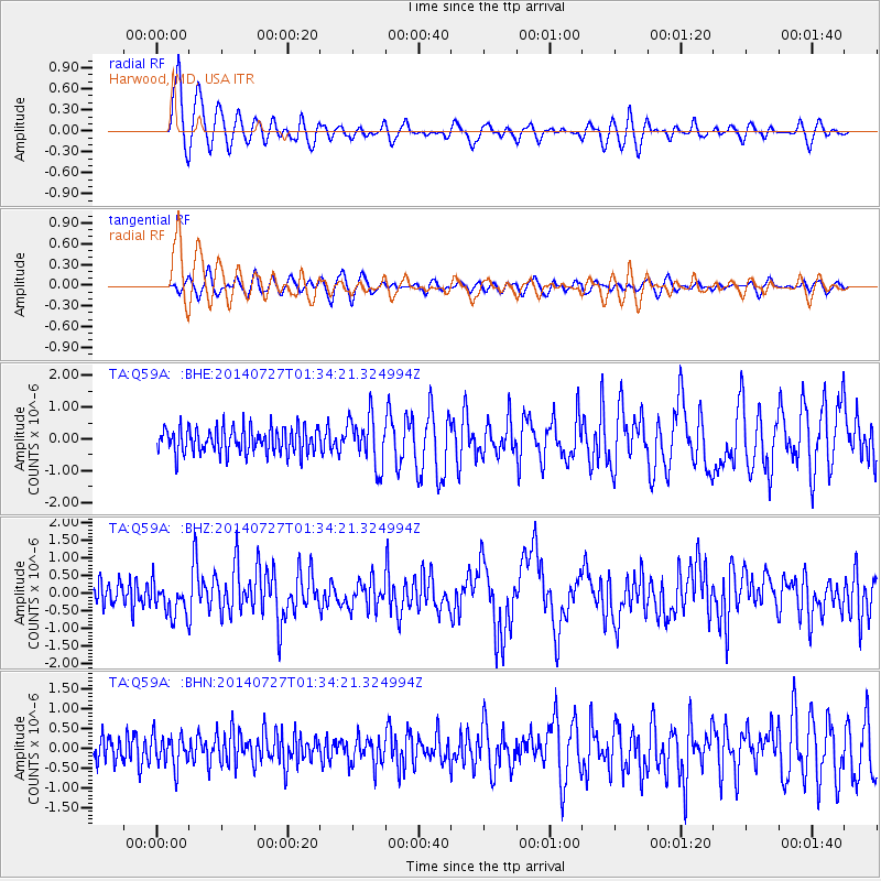
Q59A Harwood, MD, USA - Earthquake Result Viewer
*The percent match for this event was below the threshold and hence no stack was calculated.
| Earthquake location: |
Northern Mid-Atlantic Ridge |
| Earthquake latitude/longitude: |
23.8/-45.6 |
| Earthquake time(UTC): |
2014/07/27 (208) 01:28:38 GMT |
| Earthquake Depth: |
10 km |
| Earthquake Magnitude: |
5.6 MB, 6.0 MWB, 6.6 MI |
| Earthquake Catalog/Contributor: |
NEIC PDE/NEIC COMCAT |
|
| Network: |
TA USArray Transportable Network (new EarthScope stations) |
| Station: |
Q59A Harwood, MD, USA |
| Lat/Lon: |
38.86 N/76.65 W |
| Elevation: |
34 m |
|
| Distance: |
30.3 deg |
| Az: |
307.128 deg |
| Baz: |
110.657 deg |
| Ray Param: |
$rayparam |
*The percent match for this event was below the threshold and hence was not used in the summary stack. |
|
| Radial Match: |
80.20978 % |
| Radial Bump: |
400 |
| Transverse Match: |
64.6498 % |
| Transverse Bump: |
400 |
| SOD ConfigId: |
3390531 |
| Insert Time: |
2019-04-13 01:25:52.590 +0000 |
| GWidth: |
2.5 |
| Max Bumps: |
400 |
| Tol: |
0.001 |
|
Signal To Noise
| Channel | StoN | STA | LTA |
| TA:Q59A: :BHZ:20140727T01:34:21.324994Z | 1.6077732 | 5.137792E-7 | 3.1955952E-7 |
| TA:Q59A: :BHN:20140727T01:34:21.324994Z | 1.2222507 | 4.0063583E-7 | 3.277853E-7 |
| TA:Q59A: :BHE:20140727T01:34:21.324994Z | 0.962411 | 3.9411304E-7 | 4.09506E-7 |
| Arrivals |
| Ps | |
| PpPs | |
| PsPs/PpSs | |


