You are here: Home > Network List > TA - USArray Transportable Network (new EarthScope stations) Stations List
> Station 355A Pearson, GA, USA > Earthquake Result Viewer
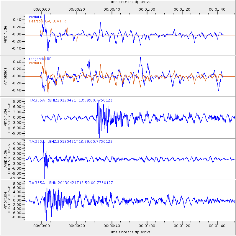
355A Pearson, GA, USA - Earthquake Result Viewer
*The percent match for this event was below the threshold and hence no stack was calculated.
| Earthquake location: |
Andreanof Islands, Aleutian Is. |
| Earthquake latitude/longitude: |
51.7/-178.2 |
| Earthquake time(UTC): |
2013/04/21 (111) 13:48:29 GMT |
| Earthquake Depth: |
44 km |
| Earthquake Magnitude: |
5.6 MW, 5.7 MW, 5.9 MB |
| Earthquake Catalog/Contributor: |
NEIC PDE/NEIC PDE-W |
|
| Network: |
TA USArray Transportable Network (new EarthScope stations) |
| Station: |
355A Pearson, GA, USA |
| Lat/Lon: |
31.34 N/82.85 W |
| Elevation: |
69 m |
|
| Distance: |
69.2 deg |
| Az: |
65.665 deg |
| Baz: |
318.449 deg |
| Ray Param: |
$rayparam |
*The percent match for this event was below the threshold and hence was not used in the summary stack. |
|
| Radial Match: |
56.421524 % |
| Radial Bump: |
400 |
| Transverse Match: |
74.04819 % |
| Transverse Bump: |
400 |
| SOD ConfigId: |
512894 |
| Insert Time: |
2013-09-13 17:17:32.108 +0000 |
| GWidth: |
2.5 |
| Max Bumps: |
400 |
| Tol: |
0.001 |
|
Signal To Noise
| Channel | StoN | STA | LTA |
| TA:355A: :BHZ:20130421T13:59:00.775012Z | 4.2463927 | 3.4467637E-6 | 8.116922E-7 |
| TA:355A: :BHN:20130421T13:59:00.775012Z | 3.6993382 | 3.128512E-6 | 8.45695E-7 |
| TA:355A: :BHE:20130421T13:59:00.775012Z | 4.5730553 | 4.1474827E-6 | 9.0693914E-7 |
| Arrivals |
| Ps | |
| PpPs | |
| PsPs/PpSs | |


