You are here: Home > Network List > TA - USArray Transportable Network (new EarthScope stations) Stations List
> Station B05D Stanwood, WA, USA > Earthquake Result Viewer
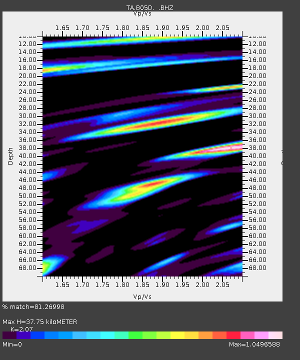
B05D Stanwood, WA, USA - Earthquake Result Viewer
| Earthquake location: |
Andreanof Islands, Aleutian Is. |
| Earthquake latitude/longitude: |
51.7/-178.2 |
| Earthquake time(UTC): |
2013/04/21 (111) 13:48:29 GMT |
| Earthquake Depth: |
44 km |
| Earthquake Magnitude: |
5.6 MW, 5.7 MW, 5.9 MB |
| Earthquake Catalog/Contributor: |
NEIC PDE/NEIC PDE-W |
|
| Network: |
TA USArray Transportable Network (new EarthScope stations) |
| Station: |
B05D Stanwood, WA, USA |
| Lat/Lon: |
48.26 N/122.10 W |
| Elevation: |
153 m |
|
| Distance: |
35.5 deg |
| Az: |
72.763 deg |
| Baz: |
297.091 deg |
| Ray Param: |
0.07707781 |
| Estimated Moho Depth: |
37.75 km |
| Estimated Crust Vp/Vs: |
2.07 |
| Assumed Crust Vp: |
6.566 km/s |
| Estimated Crust Vs: |
3.172 km/s |
| Estimated Crust Poisson's Ratio: |
0.35 |
|
| Radial Match: |
81.26998 % |
| Radial Bump: |
400 |
| Transverse Match: |
78.736534 % |
| Transverse Bump: |
400 |
| SOD ConfigId: |
512894 |
| Insert Time: |
2013-09-13 17:19:13.273 +0000 |
| GWidth: |
2.5 |
| Max Bumps: |
400 |
| Tol: |
0.001 |
|

Signal To Noise
| Channel | StoN | STA | LTA |
| TA:B05D: :BHZ:20130421T13:54:51.775012Z | 20.872368 | 1.6946773E-6 | 8.119238E-8 |
| TA:B05D: :BHN:20130421T13:54:51.775012Z | 8.464599 | 5.55532E-7 | 6.563005E-8 |
| TA:B05D: :BHE:20130421T13:54:51.775012Z | 16.683344 | 9.015772E-7 | 5.404056E-8 |
| Arrivals |
| Ps | 6.6 SECOND |
| PpPs | 16 SECOND |
| PsPs/PpSs | 23 SECOND |


