You are here: Home > Network List > TA - USArray Transportable Network (new EarthScope stations) Stations List
> Station F39A Loretta, WI, USA > Earthquake Result Viewer
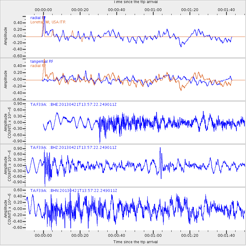
F39A Loretta, WI, USA - Earthquake Result Viewer
*The percent match for this event was below the threshold and hence no stack was calculated.
| Earthquake location: |
Andreanof Islands, Aleutian Is. |
| Earthquake latitude/longitude: |
51.7/-178.2 |
| Earthquake time(UTC): |
2013/04/21 (111) 13:48:29 GMT |
| Earthquake Depth: |
44 km |
| Earthquake Magnitude: |
5.6 MW, 5.7 MW, 5.9 MB |
| Earthquake Catalog/Contributor: |
NEIC PDE/NEIC PDE-W |
|
| Network: |
TA USArray Transportable Network (new EarthScope stations) |
| Station: |
F39A Loretta, WI, USA |
| Lat/Lon: |
45.92 N/90.92 W |
| Elevation: |
440 m |
|
| Distance: |
54.5 deg |
| Az: |
58.916 deg |
| Baz: |
310.176 deg |
| Ray Param: |
$rayparam |
*The percent match for this event was below the threshold and hence was not used in the summary stack. |
|
| Radial Match: |
58.45151 % |
| Radial Bump: |
400 |
| Transverse Match: |
55.513382 % |
| Transverse Bump: |
400 |
| SOD ConfigId: |
512894 |
| Insert Time: |
2013-09-13 17:20:57.773 +0000 |
| GWidth: |
2.5 |
| Max Bumps: |
400 |
| Tol: |
0.001 |
|
Signal To Noise
| Channel | StoN | STA | LTA |
| TA:F39A: :BHZ:20130421T13:57:22.249011Z | 1.5722592 | 4.226299E-7 | 2.6880423E-7 |
| TA:F39A: :BHN:20130421T13:57:22.249011Z | 1.0585473 | 2.6945318E-7 | 2.5454997E-7 |
| TA:F39A: :BHE:20130421T13:57:22.249011Z | 1.6307899 | 3.2358045E-7 | 1.9841947E-7 |
| Arrivals |
| Ps | |
| PpPs | |
| PsPs/PpSs | |


