You are here: Home > Network List > TA - USArray Transportable Network (new EarthScope stations) Stations List
> Station I43A Langenfeld Brothers Farm, Elkhart Lake, WI, USA > Earthquake Result Viewer
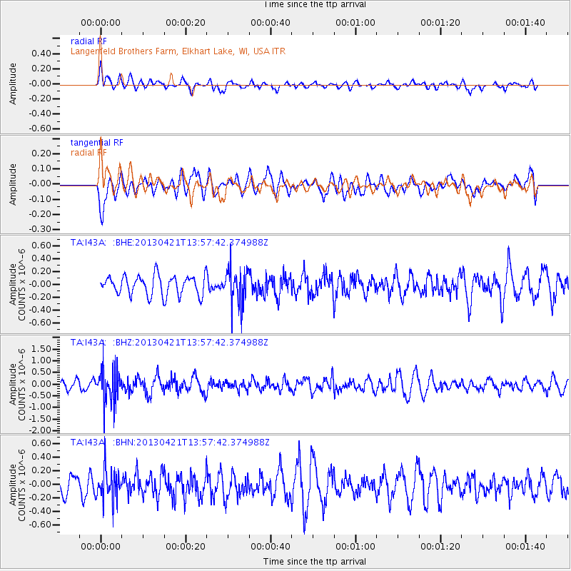
I43A Langenfeld Brothers Farm, Elkhart Lake, WI, USA - Earthquake Result Viewer
*The percent match for this event was below the threshold and hence no stack was calculated.
| Earthquake location: |
Andreanof Islands, Aleutian Is. |
| Earthquake latitude/longitude: |
51.7/-178.2 |
| Earthquake time(UTC): |
2013/04/21 (111) 13:48:29 GMT |
| Earthquake Depth: |
44 km |
| Earthquake Magnitude: |
5.6 MW, 5.7 MW, 5.9 MB |
| Earthquake Catalog/Contributor: |
NEIC PDE/NEIC PDE-W |
|
| Network: |
TA USArray Transportable Network (new EarthScope stations) |
| Station: |
I43A Langenfeld Brothers Farm, Elkhart Lake, WI, USA |
| Lat/Lon: |
43.88 N/88.15 W |
| Elevation: |
299 m |
|
| Distance: |
57.3 deg |
| Az: |
59.192 deg |
| Baz: |
312.282 deg |
| Ray Param: |
$rayparam |
*The percent match for this event was below the threshold and hence was not used in the summary stack. |
|
| Radial Match: |
40.801685 % |
| Radial Bump: |
400 |
| Transverse Match: |
52.708694 % |
| Transverse Bump: |
400 |
| SOD ConfigId: |
512894 |
| Insert Time: |
2013-09-13 17:23:19.297 +0000 |
| GWidth: |
2.5 |
| Max Bumps: |
400 |
| Tol: |
0.001 |
|
Signal To Noise
| Channel | StoN | STA | LTA |
| TA:I43A: :BHZ:20130421T13:57:42.374988Z | 5.0363135 | 7.286733E-7 | 1.4468387E-7 |
| TA:I43A: :BHN:20130421T13:57:42.374988Z | 2.1679301 | 2.263949E-7 | 1.04429056E-7 |
| TA:I43A: :BHE:20130421T13:57:42.374988Z | 1.8545823 | 2.785792E-7 | 1.5021129E-7 |
| Arrivals |
| Ps | |
| PpPs | |
| PsPs/PpSs | |


