You are here: Home > Network List > TA - USArray Transportable Network (new EarthScope stations) Stations List
> Station L42A Oliver, Polo, IL, USA > Earthquake Result Viewer
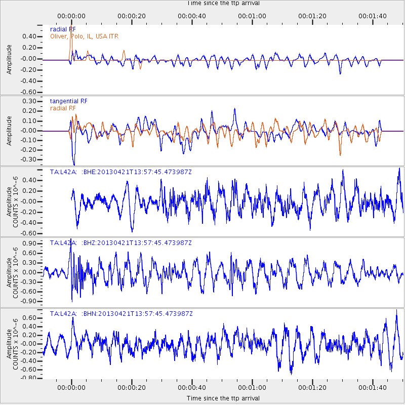
L42A Oliver, Polo, IL, USA - Earthquake Result Viewer
*The percent match for this event was below the threshold and hence no stack was calculated.
| Earthquake location: |
Andreanof Islands, Aleutian Is. |
| Earthquake latitude/longitude: |
51.7/-178.2 |
| Earthquake time(UTC): |
2013/04/21 (111) 13:48:29 GMT |
| Earthquake Depth: |
44 km |
| Earthquake Magnitude: |
5.6 MW, 5.7 MW, 5.9 MB |
| Earthquake Catalog/Contributor: |
NEIC PDE/NEIC PDE-W |
|
| Network: |
TA USArray Transportable Network (new EarthScope stations) |
| Station: |
L42A Oliver, Polo, IL, USA |
| Lat/Lon: |
42.00 N/89.67 W |
| Elevation: |
257 m |
|
| Distance: |
57.8 deg |
| Az: |
61.728 deg |
| Baz: |
312.61 deg |
| Ray Param: |
$rayparam |
*The percent match for this event was below the threshold and hence was not used in the summary stack. |
|
| Radial Match: |
56.192245 % |
| Radial Bump: |
400 |
| Transverse Match: |
50.07986 % |
| Transverse Bump: |
400 |
| SOD ConfigId: |
512894 |
| Insert Time: |
2013-09-13 17:25:46.893 +0000 |
| GWidth: |
2.5 |
| Max Bumps: |
400 |
| Tol: |
0.001 |
|
Signal To Noise
| Channel | StoN | STA | LTA |
| TA:L42A: :BHZ:20130421T13:57:45.473987Z | 2.4537401 | 4.3922446E-7 | 1.7900204E-7 |
| TA:L42A: :BHN:20130421T13:57:45.473987Z | 1.4230653 | 2.5415912E-7 | 1.7859978E-7 |
| TA:L42A: :BHE:20130421T13:57:45.473987Z | 1.0361665 | 1.890858E-7 | 1.824859E-7 |
| Arrivals |
| Ps | |
| PpPs | |
| PsPs/PpSs | |


