You are here: Home > Network List > TA - USArray Transportable Network (new EarthScope stations) Stations List
> Station P50A Jamestown, OH, USA > Earthquake Result Viewer
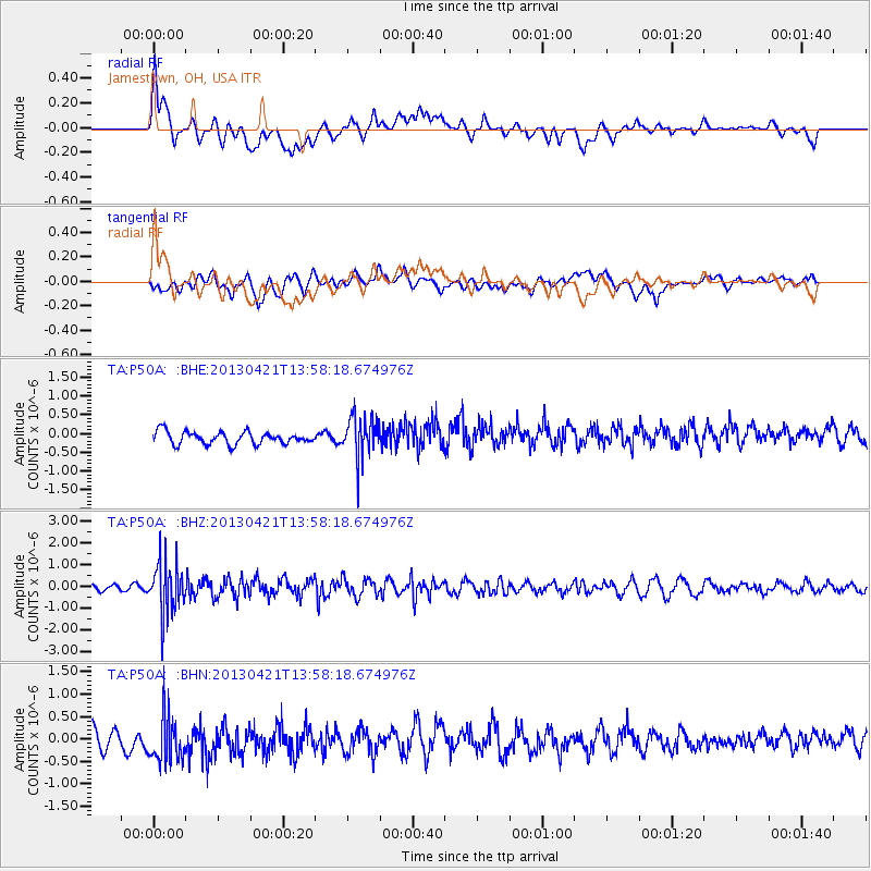
P50A Jamestown, OH, USA - Earthquake Result Viewer
*The percent match for this event was below the threshold and hence no stack was calculated.
| Earthquake location: |
Andreanof Islands, Aleutian Is. |
| Earthquake latitude/longitude: |
51.7/-178.2 |
| Earthquake time(UTC): |
2013/04/21 (111) 13:48:29 GMT |
| Earthquake Depth: |
44 km |
| Earthquake Magnitude: |
5.6 MW, 5.7 MW, 5.9 MB |
| Earthquake Catalog/Contributor: |
NEIC PDE/NEIC PDE-W |
|
| Network: |
TA USArray Transportable Network (new EarthScope stations) |
| Station: |
P50A Jamestown, OH, USA |
| Lat/Lon: |
39.61 N/83.80 W |
| Elevation: |
318 m |
|
| Distance: |
62.6 deg |
| Az: |
60.133 deg |
| Baz: |
315.639 deg |
| Ray Param: |
$rayparam |
*The percent match for this event was below the threshold and hence was not used in the summary stack. |
|
| Radial Match: |
44.6516 % |
| Radial Bump: |
400 |
| Transverse Match: |
62.479633 % |
| Transverse Bump: |
400 |
| SOD ConfigId: |
512894 |
| Insert Time: |
2013-09-13 17:29:21.623 +0000 |
| GWidth: |
2.5 |
| Max Bumps: |
400 |
| Tol: |
0.001 |
|
Signal To Noise
| Channel | StoN | STA | LTA |
| TA:P50A: :BHZ:20130421T13:58:18.674976Z | 9.879545 | 1.1932763E-6 | 1.2078252E-7 |
| TA:P50A: :BHN:20130421T13:58:18.674976Z | 2.7522273 | 5.598089E-7 | 2.0340212E-7 |
| TA:P50A: :BHE:20130421T13:58:18.674976Z | 3.4106395 | 5.677224E-7 | 1.6645629E-7 |
| Arrivals |
| Ps | |
| PpPs | |
| PsPs/PpSs | |


