You are here: Home > Network List > TA - USArray Transportable Network (new EarthScope stations) Stations List
> Station W46A Michie, TN, USA > Earthquake Result Viewer
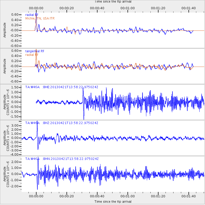
W46A Michie, TN, USA - Earthquake Result Viewer
*The percent match for this event was below the threshold and hence no stack was calculated.
| Earthquake location: |
Andreanof Islands, Aleutian Is. |
| Earthquake latitude/longitude: |
51.7/-178.2 |
| Earthquake time(UTC): |
2013/04/21 (111) 13:48:29 GMT |
| Earthquake Depth: |
44 km |
| Earthquake Magnitude: |
5.6 MW, 5.7 MW, 5.9 MB |
| Earthquake Catalog/Contributor: |
NEIC PDE/NEIC PDE-W |
|
| Network: |
TA USArray Transportable Network (new EarthScope stations) |
| Station: |
W46A Michie, TN, USA |
| Lat/Lon: |
35.13 N/88.38 W |
| Elevation: |
145 m |
|
| Distance: |
63.3 deg |
| Az: |
66.566 deg |
| Baz: |
315.794 deg |
| Ray Param: |
$rayparam |
*The percent match for this event was below the threshold and hence was not used in the summary stack. |
|
| Radial Match: |
71.253204 % |
| Radial Bump: |
400 |
| Transverse Match: |
63.390354 % |
| Transverse Bump: |
400 |
| SOD ConfigId: |
512894 |
| Insert Time: |
2013-09-13 17:34:02.094 +0000 |
| GWidth: |
2.5 |
| Max Bumps: |
400 |
| Tol: |
0.001 |
|
Signal To Noise
| Channel | StoN | STA | LTA |
| TA:W46A: :BHZ:20130421T13:58:22.975024Z | 8.65946 | 1.1559529E-6 | 1.3349018E-7 |
| TA:W46A: :BHN:20130421T13:58:22.975024Z | 3.9551167 | 8.693824E-7 | 2.1981207E-7 |
| TA:W46A: :BHE:20130421T13:58:22.975024Z | 6.406195 | 5.989682E-7 | 9.349827E-8 |
| Arrivals |
| Ps | |
| PpPs | |
| PsPs/PpSs | |


