You are here: Home > Network List > UU - University of Utah Regional Network Stations List
> Station CCUT Cedar City, UT, USA > Earthquake Result Viewer
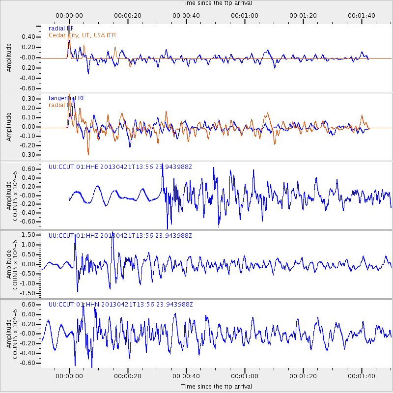
CCUT Cedar City, UT, USA - Earthquake Result Viewer
*The percent match for this event was below the threshold and hence no stack was calculated.
| Earthquake location: |
Andreanof Islands, Aleutian Is. |
| Earthquake latitude/longitude: |
51.7/-178.2 |
| Earthquake time(UTC): |
2013/04/21 (111) 13:48:29 GMT |
| Earthquake Depth: |
44 km |
| Earthquake Magnitude: |
5.6 MW, 5.7 MW, 5.9 MB |
| Earthquake Catalog/Contributor: |
NEIC PDE/NEIC PDE-W |
|
| Network: |
UU University of Utah Regional Network |
| Station: |
CCUT Cedar City, UT, USA |
| Lat/Lon: |
37.55 N/113.36 W |
| Elevation: |
2127 m |
|
| Distance: |
46.8 deg |
| Az: |
80.998 deg |
| Baz: |
309.284 deg |
| Ray Param: |
$rayparam |
*The percent match for this event was below the threshold and hence was not used in the summary stack. |
|
| Radial Match: |
59.21713 % |
| Radial Bump: |
400 |
| Transverse Match: |
65.51462 % |
| Transverse Bump: |
400 |
| SOD ConfigId: |
512894 |
| Insert Time: |
2013-09-13 17:39:46.878 +0000 |
| GWidth: |
2.5 |
| Max Bumps: |
400 |
| Tol: |
0.001 |
|
Signal To Noise
| Channel | StoN | STA | LTA |
| UU:CCUT:01:HHZ:20130421T13:56:23.943988Z | 4.683851 | 5.425292E-7 | 1.1582974E-7 |
| UU:CCUT:01:HHN:20130421T13:56:23.943988Z | 2.111757 | 2.3201396E-7 | 1.0986774E-7 |
| UU:CCUT:01:HHE:20130421T13:56:23.943988Z | 2.3525524 | 2.549845E-7 | 1.08386324E-7 |
| Arrivals |
| Ps | |
| PpPs | |
| PsPs/PpSs | |


