You are here: Home > Network List > UU - University of Utah Regional Network Stations List
> Station RDMU Red Mountain, UT, USA > Earthquake Result Viewer
RDMU Red Mountain, UT, USA - Earthquake Result Viewer
| Earthquake location: |
Andreanof Islands, Aleutian Is. |
| Earthquake latitude/longitude: |
51.7/-178.2 |
| Earthquake time(UTC): |
2013/04/21 (111) 13:48:29 GMT |
| Earthquake Depth: |
44 km |
| Earthquake Magnitude: |
5.6 MW, 5.7 MW, 5.9 MB |
| Earthquake Catalog/Contributor: |
NEIC PDE/NEIC PDE-W |
|
| Network: |
UU University of Utah Regional Network |
| Station: |
RDMU Red Mountain, UT, USA |
| Lat/Lon: |
40.57 N/109.57 W |
| Elevation: |
2087 m |
|
| Distance: |
47.2 deg |
| Az: |
75.255 deg |
| Baz: |
307.747 deg |
| Ray Param: |
0.07003753 |
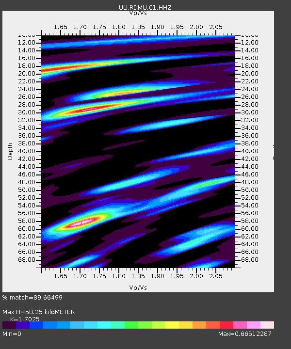
| Estimated Moho Depth: |
58.25 km |
| Estimated Crust Vp/Vs: |
1.70 |
| Assumed Crust Vp: |
6.207 km/s |
| Estimated Crust Vs: |
3.646 km/s |
| Estimated Crust Poisson's Ratio: |
0.24 |
|
| Radial Match: |
89.66499 % |
| Radial Bump: |
356 |
| Transverse Match: |
66.92608 % |
| Transverse Bump: |
400 |
| SOD ConfigId: |
512894 |
| Insert Time: |
2013-09-13 17:40:30.808 +0000 |
| GWidth: |
2.5 |
| Max Bumps: |
400 |
| Tol: |
0.001 |
|

Signal To Noise
| Channel | StoN | STA | LTA |
| UU:RDMU:01:HHZ:20130421T13:56:27.319995Z | 16.3203 | 5.725327E-8 | 3.508102E-9 |
| UU:RDMU:01:HHN:20130421T13:56:27.319995Z | 8.9845085 | 2.1940492E-8 | 2.4420357E-9 |
| UU:RDMU:01:HHE:20130421T13:56:27.319995Z | 6.1494536 | 1.804739E-8 | 2.9347955E-9 |
| Arrivals |
| Ps | 7.0 SECOND |
| PpPs | 24 SECOND |
| PsPs/PpSs | 31 SECOND |


