You are here: Home > Network List > UW - Pacific Northwest Regional Seismic Network Stations List
> Station LEBA Lebam, WA, USA > Earthquake Result Viewer
LEBA Lebam, WA, USA - Earthquake Result Viewer
*The percent match for this event was below the threshold and hence no stack was calculated.
| Earthquake location: |
Andreanof Islands, Aleutian Is. |
| Earthquake latitude/longitude: |
51.7/-178.2 |
| Earthquake time(UTC): |
2013/04/21 (111) 13:48:29 GMT |
| Earthquake Depth: |
44 km |
| Earthquake Magnitude: |
5.6 MW, 5.7 MW, 5.9 MB |
| Earthquake Catalog/Contributor: |
NEIC PDE/NEIC PDE-W |
|
| Network: |
UW Pacific Northwest Regional Seismic Network |
| Station: |
LEBA Lebam, WA, USA |
| Lat/Lon: |
46.55 N/123.56 W |
| Elevation: |
73 m |
|
| Distance: |
35.4 deg |
| Az: |
76.184 deg |
| Baz: |
298.801 deg |
| Ray Param: |
$rayparam |
*The percent match for this event was below the threshold and hence was not used in the summary stack. |
|
| Radial Match: |
74.04095 % |
| Radial Bump: |
400 |
| Transverse Match: |
79.51715 % |
| Transverse Bump: |
400 |
| SOD ConfigId: |
512894 |
| Insert Time: |
2013-09-13 17:41:40.517 +0000 |
| GWidth: |
2.5 |
| Max Bumps: |
400 |
| Tol: |
0.001 |
|
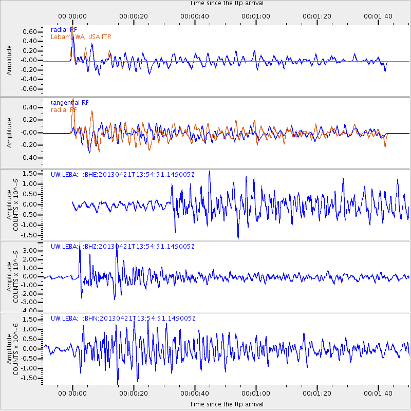
Signal To Noise
| Channel | StoN | STA | LTA |
| UW:LEBA: :BHZ:20130421T13:54:51.149005Z | 7.859614 | 1.1470324E-6 | 1.4594005E-7 |
| UW:LEBA: :BHN:20130421T13:54:51.149005Z | 2.8610327 | 4.6800582E-7 | 1.6357933E-7 |
| UW:LEBA: :BHE:20130421T13:54:51.149005Z | 3.4013257 | 4.4042795E-7 | 1.2948715E-7 |
| Arrivals |
| Ps | |
| PpPs | |
| PsPs/PpSs | |


