You are here: Home > Network List > CN - Canadian National Seismograph Network Stations List
> Station KAPO KAPUSKASING, ON > Earthquake Result Viewer
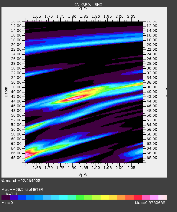
KAPO KAPUSKASING, ON - Earthquake Result Viewer
| Earthquake location: |
Michoacan, Mexico |
| Earthquake latitude/longitude: |
18.1/-102.2 |
| Earthquake time(UTC): |
2013/04/22 (112) 01:16:32 GMT |
| Earthquake Depth: |
30 km |
| Earthquake Magnitude: |
6.0 MW, 5.6 MB, 5.9 MS, 5.9 MW |
| Earthquake Catalog/Contributor: |
NEIC PDE/NEIC PDE-W |
|
| Network: |
CN Canadian National Seismograph Network |
| Station: |
KAPO KAPUSKASING, ON |
| Lat/Lon: |
49.45 N/82.51 W |
| Elevation: |
210 m |
|
| Distance: |
35.1 deg |
| Az: |
22.473 deg |
| Baz: |
213.858 deg |
| Ray Param: |
0.07735571 |
| Estimated Moho Depth: |
66.5 km |
| Estimated Crust Vp/Vs: |
1.60 |
| Assumed Crust Vp: |
6.467 km/s |
| Estimated Crust Vs: |
4.042 km/s |
| Estimated Crust Poisson's Ratio: |
0.18 |
|
| Radial Match: |
92.464905 % |
| Radial Bump: |
245 |
| Transverse Match: |
64.72296 % |
| Transverse Bump: |
400 |
| SOD ConfigId: |
512894 |
| Insert Time: |
2013-09-13 17:50:23.786 +0000 |
| GWidth: |
2.5 |
| Max Bumps: |
400 |
| Tol: |
0.001 |
|

Signal To Noise
| Channel | StoN | STA | LTA |
| CN:KAPO: :BHZ:20130422T01:22:52.799991Z | 5.4678006 | 1.0568422E-6 | 1.9328469E-7 |
| CN:KAPO: :BHN:20130422T01:22:52.799991Z | 2.2993567 | 5.6368356E-7 | 2.4514836E-7 |
| CN:KAPO: :BHE:20130422T01:22:52.799991Z | 4.2281 | 4.5097718E-7 | 1.0666191E-7 |
| Arrivals |
| Ps | 6.7 SECOND |
| PpPs | 25 SECOND |
| PsPs/PpSs | 31 SECOND |


