You are here: Home > Network List > GT - Global Telemetered Seismograph Network (USAF/USGS) Stations List
> Station LPAZ La Paz , Bolivia > Earthquake Result Viewer
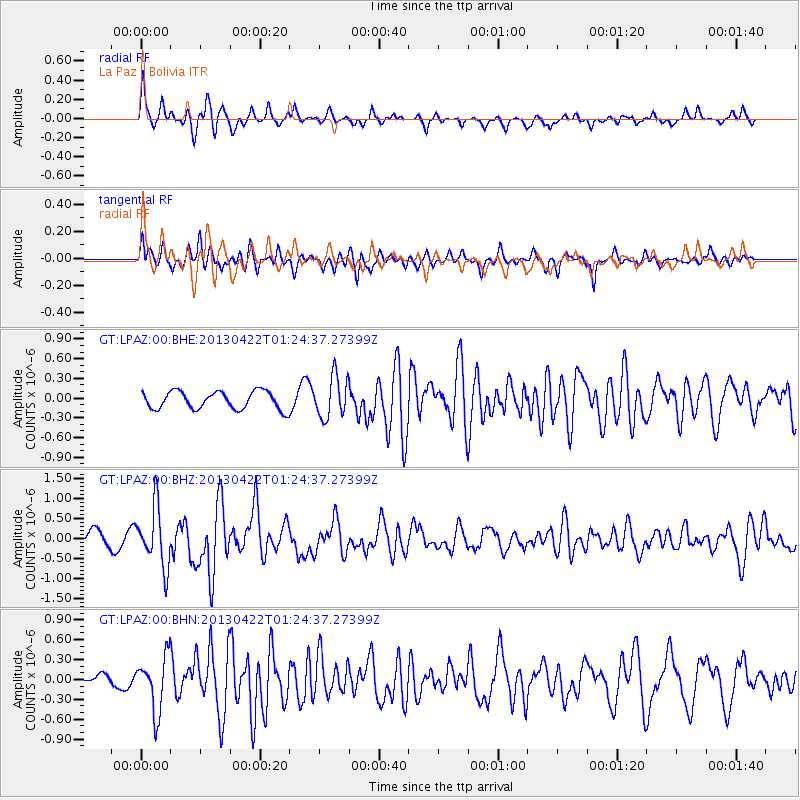
LPAZ La Paz , Bolivia - Earthquake Result Viewer
*The percent match for this event was below the threshold and hence no stack was calculated.
| Earthquake location: |
Michoacan, Mexico |
| Earthquake latitude/longitude: |
18.1/-102.2 |
| Earthquake time(UTC): |
2013/04/22 (112) 01:16:32 GMT |
| Earthquake Depth: |
30 km |
| Earthquake Magnitude: |
6.0 MW, 5.6 MB, 5.9 MS, 5.9 MW |
| Earthquake Catalog/Contributor: |
NEIC PDE/NEIC PDE-W |
|
| Network: |
GT Global Telemetered Seismograph Network (USAF/USGS) |
| Station: |
LPAZ La Paz , Bolivia |
| Lat/Lon: |
16.17 S/68.08 W |
| Elevation: |
4817 m |
|
| Distance: |
47.8 deg |
| Az: |
133.359 deg |
| Baz: |
313.967 deg |
| Ray Param: |
$rayparam |
*The percent match for this event was below the threshold and hence was not used in the summary stack. |
|
| Radial Match: |
74.02117 % |
| Radial Bump: |
359 |
| Transverse Match: |
66.9992 % |
| Transverse Bump: |
400 |
| SOD ConfigId: |
512894 |
| Insert Time: |
2013-09-13 17:52:53.341 +0000 |
| GWidth: |
2.5 |
| Max Bumps: |
400 |
| Tol: |
0.001 |
|
Signal To Noise
| Channel | StoN | STA | LTA |
| GT:LPAZ:00:BHZ:20130422T01:24:37.27399Z | 3.8443205 | 7.4055856E-7 | 1.9263706E-7 |
| GT:LPAZ:00:BHN:20130422T01:24:37.27399Z | 5.003937 | 4.206345E-7 | 8.406071E-8 |
| GT:LPAZ:00:BHE:20130422T01:24:37.27399Z | 2.2969189 | 3.0518575E-7 | 1.3286746E-7 |
| Arrivals |
| Ps | |
| PpPs | |
| PsPs/PpSs | |


