You are here: Home > Network List > LD - Lamont-Doherty Cooperative Seismographic Network Stations List
> Station KSCT Kent School, Kent, Conneticut > Earthquake Result Viewer
KSCT Kent School, Kent, Conneticut - Earthquake Result Viewer
| Earthquake location: |
Michoacan, Mexico |
| Earthquake latitude/longitude: |
18.1/-102.2 |
| Earthquake time(UTC): |
2013/04/22 (112) 01:16:32 GMT |
| Earthquake Depth: |
30 km |
| Earthquake Magnitude: |
6.0 MW, 5.6 MB, 5.9 MS, 5.9 MW |
| Earthquake Catalog/Contributor: |
NEIC PDE/NEIC PDE-W |
|
| Network: |
LD Lamont-Doherty Cooperative Seismographic Network |
| Station: |
KSCT Kent School, Kent, Conneticut |
| Lat/Lon: |
41.73 N/73.48 W |
| Elevation: |
114 m |
|
| Distance: |
34.0 deg |
| Az: |
40.012 deg |
| Baz: |
234.789 deg |
| Ray Param: |
0.07790738 |
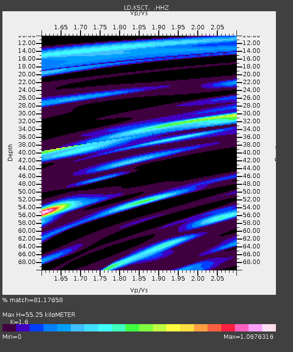
| Estimated Moho Depth: |
55.25 km |
| Estimated Crust Vp/Vs: |
1.60 |
| Assumed Crust Vp: |
6.472 km/s |
| Estimated Crust Vs: |
4.045 km/s |
| Estimated Crust Poisson's Ratio: |
0.18 |
|
| Radial Match: |
81.17658 % |
| Radial Bump: |
326 |
| Transverse Match: |
57.939037 % |
| Transverse Bump: |
325 |
| SOD ConfigId: |
512894 |
| Insert Time: |
2013-09-13 17:55:41.507 +0000 |
| GWidth: |
2.5 |
| Max Bumps: |
400 |
| Tol: |
0.001 |
|

Signal To Noise
| Channel | StoN | STA | LTA |
| LD:KSCT: :HHZ:20130422T01:22:43.35001Z | 2.0583935 | 5.846708E-7 | 2.840423E-7 |
| LD:KSCT: :HHN:20130422T01:22:43.35001Z | 1.6915877 | 3.2410577E-7 | 1.9159855E-7 |
| LD:KSCT: :HHE:20130422T01:22:43.35001Z | 1.4123087 | 3.6921583E-7 | 2.6142715E-7 |
| Arrivals |
| Ps | 5.6 SECOND |
| PpPs | 20 SECOND |
| PsPs/PpSs | 26 SECOND |


