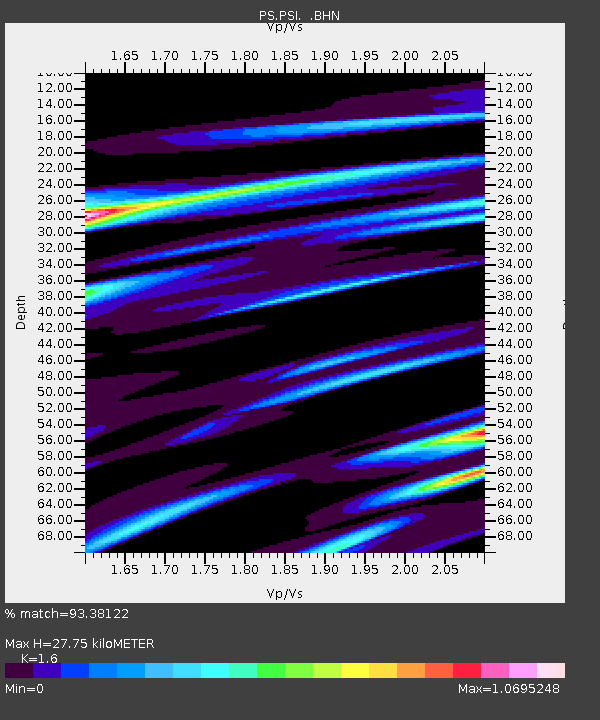
PSI Parapat, Indonesia - Earthquake Result Viewer
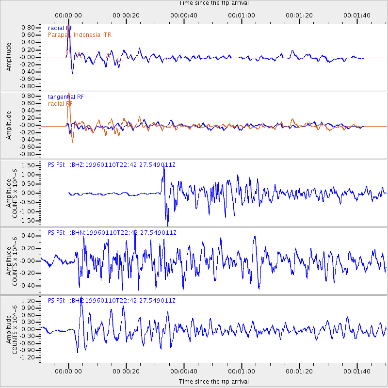
Earthquake location: Aru Islands Region, Indonesia
Earthquake latitude/longitude: -6.1/133.6
Earthquake time(UTC): 1996/01/10 (010) 22:36:03 GMT
Earthquake Depth: 37 km
Earthquake Magnitude: 5.8 MB, 5.6 MS, 6.0 UNKNOWN, 5.9 MW
Earthquake Catalog/Contributor: WHDF/NEIC
Network: PS Pacific21
Station: PSI Parapat, Indonesia
Lat/Lon: 2.69 N/98.92 E
Elevation: 987 m
Distance: 35.7 deg
Az: 283.22 deg
Baz: 104.285 deg
Ray Param: 0.07700682
Estimated Moho Depth: 27.75 km
Estimated Crust Vp/Vs: 1.60
Assumed Crust Vp: 6.468 km/s
Estimated Crust Vs: 4.042 km/s
Estimated Crust Poisson's Ratio: 0.18
Radial Match: 93.38122 %
Radial Bump: 400
Transverse Match: 80.24899 %
Transverse Bump: 400
SOD ConfigId: 6273
Insert Time: 2010-02-27 03:18:40.762 +0000
GWidth: 2.5
Max Bumps: 400
Tol: 0.001

Signal To Noise

ChannelStoNSTALTA
PS:PSI: :BHN:19960110T22:42:27.549011Z2.55717781.2503078E-74.8894048E-8
PS:PSI: :BHE:19960110T22:42:27.549011Z7.61272245.1940947E-76.822914E-8
PS:PSI: :BHZ:19960110T22:42:27.549011Z15.07385357.1165596E-74.7211284E-8
Arrivals
Ps2.8 SECOND
PpPs10 SECOND
PsPs/PpSs13 SECOND