You are here: Home > Network List > PS - Pacific21 Stations List
> Station PSI Parapat, Indonesia > Earthquake Result Viewer
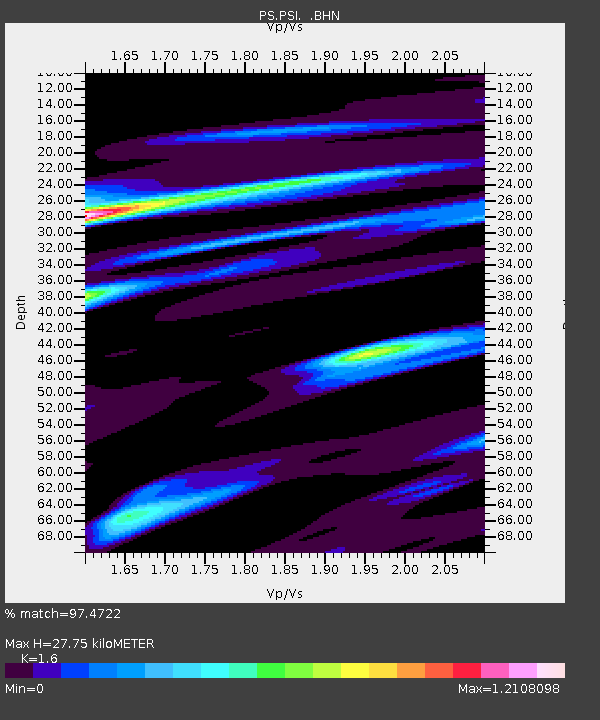
PSI Parapat, Indonesia - Earthquake Result Viewer
| Earthquake location: |
Irian Jaya, Indonesia |
| Earthquake latitude/longitude: |
-4.4/140.0 |
| Earthquake time(UTC): |
1996/01/17 (017) 10:06:45 GMT |
| Earthquake Depth: |
104 km |
| Earthquake Magnitude: |
5.6 MB, 6.1 UNKNOWN, 6.1 MW |
| Earthquake Catalog/Contributor: |
WHDF/NEIC |
|
| Network: |
PS Pacific21 |
| Station: |
PSI Parapat, Indonesia |
| Lat/Lon: |
2.69 N/98.92 E |
| Elevation: |
987 m |
|
| Distance: |
41.7 deg |
| Az: |
279.026 deg |
| Baz: |
99.677 deg |
| Ray Param: |
0.07326635 |
| Estimated Moho Depth: |
27.75 km |
| Estimated Crust Vp/Vs: |
1.60 |
| Assumed Crust Vp: |
6.468 km/s |
| Estimated Crust Vs: |
4.042 km/s |
| Estimated Crust Poisson's Ratio: |
0.18 |
|
| Radial Match: |
97.4722 % |
| Radial Bump: |
356 |
| Transverse Match: |
89.42831 % |
| Transverse Bump: |
400 |
| SOD ConfigId: |
6273 |
| Insert Time: |
2010-02-27 03:18:43.189 +0000 |
| GWidth: |
2.5 |
| Max Bumps: |
400 |
| Tol: |
0.001 |
|

Signal To Noise
| Channel | StoN | STA | LTA |
| PS:PSI: :BHN:19960117T10:13:53.200006Z | 2.708609 | 1.3299261E-7 | 4.9099963E-8 |
| PS:PSI: :BHE:19960117T10:13:53.200006Z | 10.770892 | 3.2329064E-7 | 3.0015215E-8 |
| PS:PSI: :BHZ:19960117T10:13:53.200006Z | 23.836172 | 7.6375386E-7 | 3.20418E-8 |
| Arrivals |
| Ps | 2.8 SECOND |
| PpPs | 10 SECOND |
| PsPs/PpSs | 13 SECOND |


