You are here: Home > Network List > PS - Pacific21 Stations List
> Station PSI Parapat, Indonesia > Earthquake Result Viewer
PSI Parapat, Indonesia - Earthquake Result Viewer
| Earthquake location: |
Taiwan Region |
| Earthquake latitude/longitude: |
24.1/122.2 |
| Earthquake time(UTC): |
1996/03/05 (065) 14:52:28 GMT |
| Earthquake Depth: |
30 km |
| Earthquake Magnitude: |
6.1 MB, 6.4 MS, 6.5 UNKNOWN, 5.9 MS |
| Earthquake Catalog/Contributor: |
WHDF/NEIC |
|
| Network: |
PS Pacific21 |
| Station: |
PSI Parapat, Indonesia |
| Lat/Lon: |
2.69 N/98.92 E |
| Elevation: |
987 m |
|
| Distance: |
31.0 deg |
| Az: |
230.141 deg |
| Baz: |
44.612 deg |
| Ray Param: |
0.07916655 |
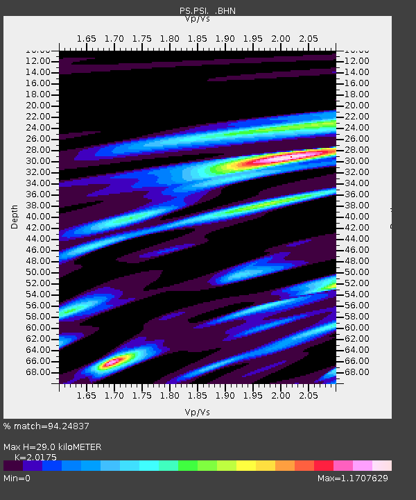
| Estimated Moho Depth: |
29.0 km |
| Estimated Crust Vp/Vs: |
2.02 |
| Assumed Crust Vp: |
6.468 km/s |
| Estimated Crust Vs: |
3.206 km/s |
| Estimated Crust Poisson's Ratio: |
0.34 |
|
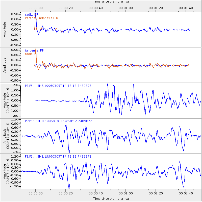
| Radial Match: |
94.24837 % |
| Radial Bump: |
310 |
| Transverse Match: |
80.63573 % |
| Transverse Bump: |
400 |
| SOD ConfigId: |
6273 |
| Insert Time: |
2010-02-27 03:18:52.915 +0000 |
| GWidth: |
2.5 |
| Max Bumps: |
400 |
| Tol: |
0.001 |
|
Signal To Noise
| Channel | StoN | STA | LTA |
| PS:PSI: :BHN:19960305T14:58:12.748987Z | 2.597621 | 8.3495586E-8 | 3.2143095E-8 |
| PS:PSI: :BHE:19960305T14:58:12.748987Z | 1.4128389 | 7.230497E-8 | 5.117708E-8 |
| PS:PSI: :BHZ:19960305T14:58:12.748987Z | 3.6840675 | 1.4251654E-7 | 3.8684565E-8 |
| Arrivals |
| Ps | 4.9 SECOND |
| PpPs | 13 SECOND |
| PsPs/PpSs | 17 SECOND |


