You are here: Home > Network List > TA - USArray Transportable Network (new EarthScope stations) Stations List
> Station D54A Lac Fusel, La Vallee-de-La-Gatineau, QC, CAN > Earthquake Result Viewer
D54A Lac Fusel, La Vallee-de-La-Gatineau, QC, CAN - Earthquake Result Viewer
| Earthquake location: |
Michoacan, Mexico |
| Earthquake latitude/longitude: |
18.1/-102.2 |
| Earthquake time(UTC): |
2013/04/22 (112) 01:16:32 GMT |
| Earthquake Depth: |
30 km |
| Earthquake Magnitude: |
6.0 MW, 5.6 MB, 5.9 MS, 5.9 MW |
| Earthquake Catalog/Contributor: |
NEIC PDE/NEIC PDE-W |
|
| Network: |
TA USArray Transportable Network (new EarthScope stations) |
| Station: |
D54A Lac Fusel, La Vallee-de-La-Gatineau, QC, CAN |
| Lat/Lon: |
47.15 N/76.66 W |
| Elevation: |
415 m |
|
| Distance: |
35.8 deg |
| Az: |
30.203 deg |
| Baz: |
224.519 deg |
| Ray Param: |
0.076988645 |
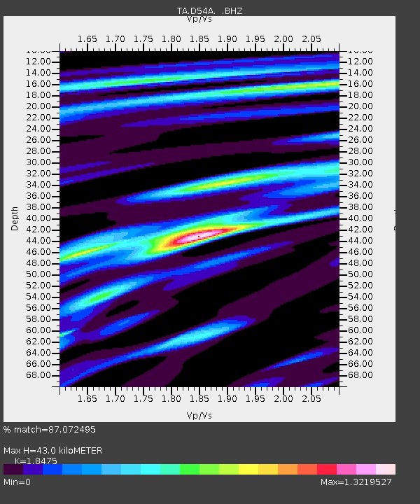
| Estimated Moho Depth: |
43.0 km |
| Estimated Crust Vp/Vs: |
1.85 |
| Assumed Crust Vp: |
6.622 km/s |
| Estimated Crust Vs: |
3.584 km/s |
| Estimated Crust Poisson's Ratio: |
0.29 |
|
| Radial Match: |
87.072495 % |
| Radial Bump: |
270 |
| Transverse Match: |
37.631573 % |
| Transverse Bump: |
400 |
| SOD ConfigId: |
512894 |
| Insert Time: |
2013-09-13 18:00:53.676 +0000 |
| GWidth: |
2.5 |
| Max Bumps: |
400 |
| Tol: |
0.001 |
|

Signal To Noise
| Channel | StoN | STA | LTA |
| TA:D54A: :BHZ:20130422T01:22:58.699985Z | 5.064437 | 7.5382695E-7 | 1.4884714E-7 |
| TA:D54A: :BHN:20130422T01:22:58.699985Z | 1.1763988 | 3.245358E-7 | 2.7587228E-7 |
| TA:D54A: :BHE:20130422T01:22:58.699985Z | 2.1084995 | 4.5817197E-7 | 2.1729765E-7 |
| Arrivals |
| Ps | 5.9 SECOND |
| PpPs | 17 SECOND |
| PsPs/PpSs | 23 SECOND |


