You are here: Home > Network List > TA - USArray Transportable Network (new EarthScope stations) Stations List
> Station F05D White Salmon, WA, USA > Earthquake Result Viewer
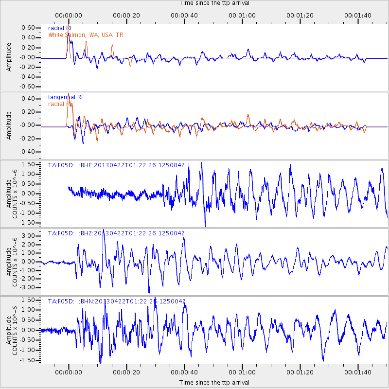
F05D White Salmon, WA, USA - Earthquake Result Viewer

| Earthquake location: |
Michoacan, Mexico |
| Earthquake latitude/longitude: |
18.1/-102.2 |
| Earthquake time(UTC): |
2013/04/22 (112) 01:16:32 GMT |
| Earthquake Depth: |
30 km |
| Earthquake Magnitude: |
6.0 MW, 5.6 MB, 5.9 MS, 5.9 MW |
| Earthquake Catalog/Contributor: |
NEIC PDE/NEIC PDE-W |
|
| Network: |
TA USArray Transportable Network (new EarthScope stations) |
| Station: |
F05D White Salmon, WA, USA |
| Lat/Lon: |
45.89 N/121.46 W |
| Elevation: |
472 m |
|
| Distance: |
32.0 deg |
| Az: |
334.213 deg |
| Baz: |
143.671 deg |
| Ray Param: |
0.07879001 |
| Estimated Moho Depth: |
16.25 km |
| Estimated Crust Vp/Vs: |
2.10 |
| Assumed Crust Vp: |
6.597 km/s |
| Estimated Crust Vs: |
3.145 km/s |
| Estimated Crust Poisson's Ratio: |
0.35 |
|
| Radial Match: |
88.533424 % |
| Radial Bump: |
400 |
| Transverse Match: |
85.582695 % |
| Transverse Bump: |
400 |
| SOD ConfigId: |
512894 |
| Insert Time: |
2013-09-13 18:01:46.514 +0000 |
| GWidth: |
2.5 |
| Max Bumps: |
400 |
| Tol: |
0.001 |
|
Signal To Noise
| Channel | StoN | STA | LTA |
| TA:F05D: :BHZ:20130422T01:22:26.125004Z | 5.1197305 | 7.9571925E-7 | 1.554221E-7 |
| TA:F05D: :BHN:20130422T01:22:26.125004Z | 2.1361496 | 3.4038283E-7 | 1.593441E-7 |
| TA:F05D: :BHE:20130422T01:22:26.125004Z | 1.4812254 | 2.1776992E-7 | 1.4702012E-7 |
| Arrivals |
| Ps | 2.9 SECOND |
| PpPs | 7.1 SECOND |
| PsPs/PpSs | 10 SECOND |


