You are here: Home > Network List > TA - USArray Transportable Network (new EarthScope stations) Stations List
> Station F49A Sandfield, ON, CAN > Earthquake Result Viewer
F49A Sandfield, ON, CAN - Earthquake Result Viewer
| Earthquake location: |
Michoacan, Mexico |
| Earthquake latitude/longitude: |
18.1/-102.2 |
| Earthquake time(UTC): |
2013/04/22 (112) 01:16:32 GMT |
| Earthquake Depth: |
30 km |
| Earthquake Magnitude: |
6.0 MW, 5.6 MB, 5.9 MS, 5.9 MW |
| Earthquake Catalog/Contributor: |
NEIC PDE/NEIC PDE-W |
|
| Network: |
TA USArray Transportable Network (new EarthScope stations) |
| Station: |
F49A Sandfield, ON, CAN |
| Lat/Lon: |
45.76 N/82.04 W |
| Elevation: |
230 m |
|
| Distance: |
32.3 deg |
| Az: |
26.83 deg |
| Baz: |
217.828 deg |
| Ray Param: |
0.07867711 |
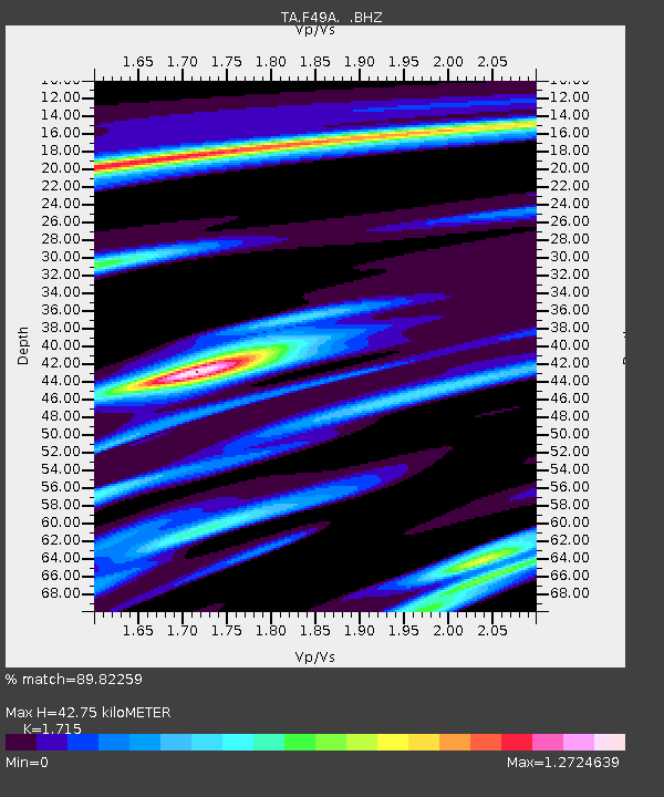
| Estimated Moho Depth: |
42.75 km |
| Estimated Crust Vp/Vs: |
1.72 |
| Assumed Crust Vp: |
6.483 km/s |
| Estimated Crust Vs: |
3.78 km/s |
| Estimated Crust Poisson's Ratio: |
0.24 |
|
| Radial Match: |
89.82259 % |
| Radial Bump: |
316 |
| Transverse Match: |
73.82251 % |
| Transverse Bump: |
390 |
| SOD ConfigId: |
512894 |
| Insert Time: |
2013-09-13 18:02:05.084 +0000 |
| GWidth: |
2.5 |
| Max Bumps: |
400 |
| Tol: |
0.001 |
|
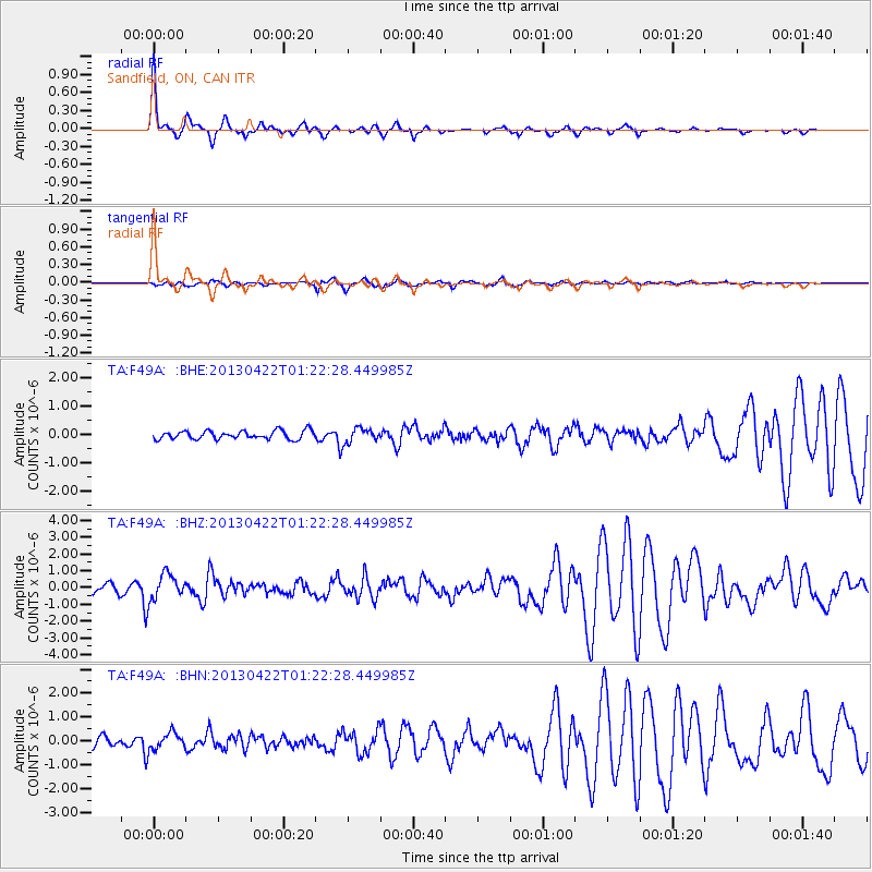
Signal To Noise
| Channel | StoN | STA | LTA |
| TA:F49A: :BHZ:20130422T01:22:28.449985Z | 3.7109416 | 7.582923E-7 | 2.0433959E-7 |
| TA:F49A: :BHN:20130422T01:22:28.449985Z | 1.975137 | 3.5210556E-7 | 1.7826893E-7 |
| TA:F49A: :BHE:20130422T01:22:28.449985Z | 1.7487931 | 2.615257E-7 | 1.495464E-7 |
| Arrivals |
| Ps | 5.1 SECOND |
| PpPs | 16 SECOND |
| PsPs/PpSs | 22 SECOND |


