You are here: Home > Network List > TA - USArray Transportable Network (new EarthScope stations) Stations List
> Station G03D McMinnville, OR, USA > Earthquake Result Viewer
G03D McMinnville, OR, USA - Earthquake Result Viewer
| Earthquake location: |
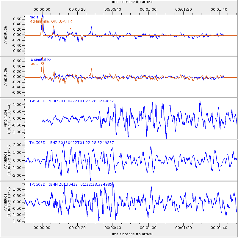
Michoacan, Mexico |
| Earthquake latitude/longitude: |
18.1/-102.2 |
| Earthquake time(UTC): |
2013/04/22 (112) 01:16:32 GMT |
| Earthquake Depth: |
30 km |
| Earthquake Magnitude: |
6.0 MW, 5.6 MB, 5.9 MS, 5.9 MW |
| Earthquake Catalog/Contributor: |
NEIC PDE/NEIC PDE-W |
|
| Network: |
TA USArray Transportable Network (new EarthScope stations) |
| Station: |
G03D McMinnville, OR, USA |
| Lat/Lon: |
45.21 N/123.26 W |
| Elevation: |
222 m |
|
| Distance: |
32.3 deg |
| Az: |
331.556 deg |
| Baz: |
140.137 deg |
| Ray Param: |
0.07868285 |
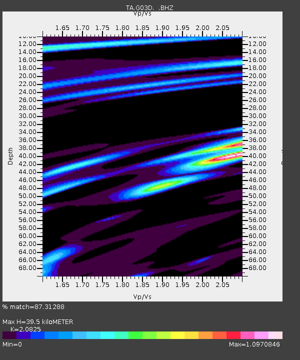
| Estimated Moho Depth: |
39.5 km |
| Estimated Crust Vp/Vs: |
2.08 |
| Assumed Crust Vp: |
6.566 km/s |
| Estimated Crust Vs: |
3.153 km/s |
| Estimated Crust Poisson's Ratio: |
0.35 |
|
| Radial Match: |
87.31288 % |
| Radial Bump: |
400 |
| Transverse Match: |
63.931095 % |
| Transverse Bump: |
400 |
| SOD ConfigId: |
512894 |
| Insert Time: |
2013-09-13 18:02:15.956 +0000 |
| GWidth: |
2.5 |
| Max Bumps: |
400 |
| Tol: |
0.001 |
|
Signal To Noise
| Channel | StoN | STA | LTA |
| TA:G03D: :BHZ:20130422T01:22:28.324985Z | 4.3152127 | 4.942544E-7 | 1.1453767E-7 |
| TA:G03D: :BHN:20130422T01:22:28.324985Z | 1.0054232 | 1.5345844E-7 | 1.5263069E-7 |
| TA:G03D: :BHE:20130422T01:22:28.324985Z | 1.7066865 | 2.4967798E-7 | 1.46294E-7 |
| Arrivals |
| Ps | 7.0 SECOND |
| PpPs | 17 SECOND |
| PsPs/PpSs | 24 SECOND |


