You are here: Home > Network List > TA - USArray Transportable Network (new EarthScope stations) Stations List
> Station I48A Sherman Twp, MI, USA > Earthquake Result Viewer
I48A Sherman Twp, MI, USA - Earthquake Result Viewer
| Earthquake location: |
Michoacan, Mexico |
| Earthquake latitude/longitude: |
18.1/-102.2 |
| Earthquake time(UTC): |
2013/04/22 (112) 01:16:32 GMT |
| Earthquake Depth: |
30 km |
| Earthquake Magnitude: |
6.0 MW, 5.6 MB, 5.9 MS, 5.9 MW |
| Earthquake Catalog/Contributor: |
NEIC PDE/NEIC PDE-W |
|
| Network: |
TA USArray Transportable Network (new EarthScope stations) |
| Station: |
I48A Sherman Twp, MI, USA |
| Lat/Lon: |
44.19 N/83.70 W |
| Elevation: |
192 m |
|
| Distance: |
30.3 deg |
| Az: |
26.86 deg |
| Baz: |
216.685 deg |
| Ray Param: |
0.07933879 |
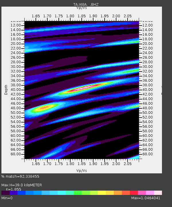
| Estimated Moho Depth: |
39.0 km |
| Estimated Crust Vp/Vs: |
1.86 |
| Assumed Crust Vp: |
6.483 km/s |
| Estimated Crust Vs: |
3.495 km/s |
| Estimated Crust Poisson's Ratio: |
0.30 |
|
| Radial Match: |
92.338455 % |
| Radial Bump: |
343 |
| Transverse Match: |
65.39639 % |
| Transverse Bump: |
400 |
| SOD ConfigId: |
512894 |
| Insert Time: |
2013-09-13 18:03:11.358 +0000 |
| GWidth: |
2.5 |
| Max Bumps: |
400 |
| Tol: |
0.001 |
|
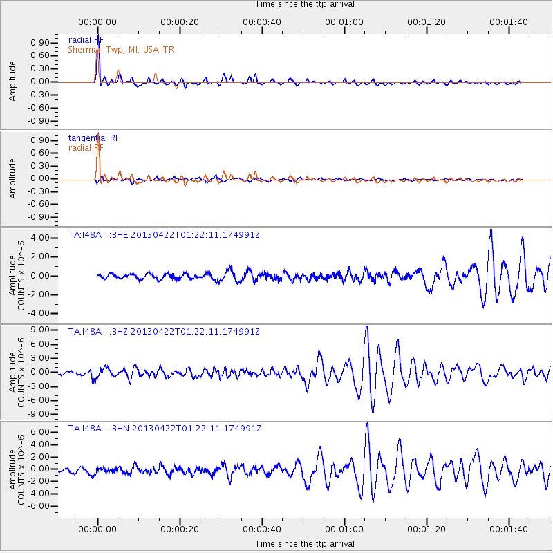
Signal To Noise
| Channel | StoN | STA | LTA |
| TA:I48A: :BHZ:20130422T01:22:11.174991Z | 1.745415 | 1.0181124E-6 | 5.833068E-7 |
| TA:I48A: :BHN:20130422T01:22:11.174991Z | 1.2145126 | 4.056175E-7 | 3.3397555E-7 |
| TA:I48A: :BHE:20130422T01:22:11.174991Z | 2.4917767 | 6.186634E-7 | 2.4828205E-7 |
| Arrivals |
| Ps | 5.6 SECOND |
| PpPs | 16 SECOND |
| PsPs/PpSs | 21 SECOND |


