You are here: Home > Network List > TA - USArray Transportable Network (new EarthScope stations) Stations List
> Station I49A Point Hope, MI, USA > Earthquake Result Viewer
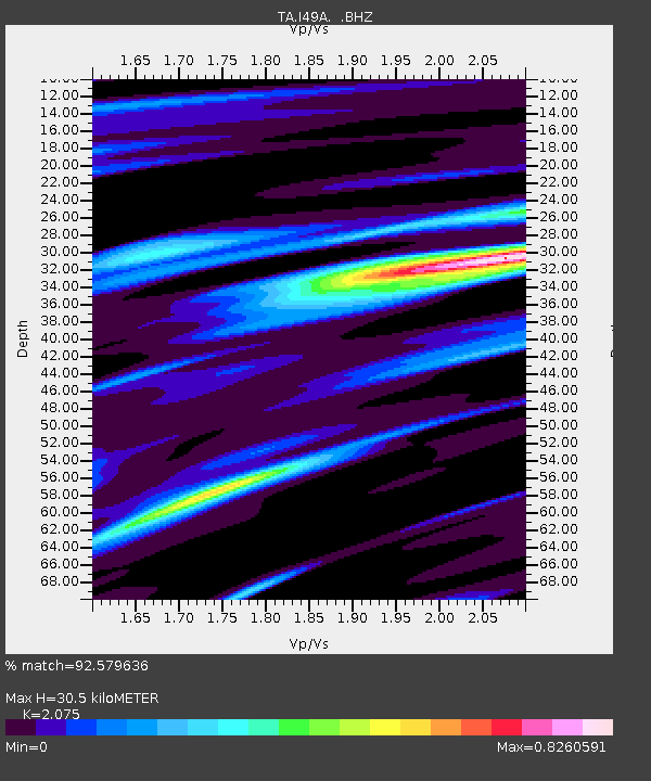
I49A Point Hope, MI, USA - Earthquake Result Viewer
| Earthquake location: |
Michoacan, Mexico |
| Earthquake latitude/longitude: |
18.1/-102.2 |
| Earthquake time(UTC): |
2013/04/22 (112) 01:16:32 GMT |
| Earthquake Depth: |
30 km |
| Earthquake Magnitude: |
6.0 MW, 5.6 MB, 5.9 MS, 5.9 MW |
| Earthquake Catalog/Contributor: |
NEIC PDE/NEIC PDE-W |
|
| Network: |
TA USArray Transportable Network (new EarthScope stations) |
| Station: |
I49A Point Hope, MI, USA |
| Lat/Lon: |
43.94 N/82.82 W |
| Elevation: |
217 m |
|
| Distance: |
30.5 deg |
| Az: |
28.149 deg |
| Baz: |
218.405 deg |
| Ray Param: |
0.07928902 |
| Estimated Moho Depth: |
30.5 km |
| Estimated Crust Vp/Vs: |
2.08 |
| Assumed Crust Vp: |
6.483 km/s |
| Estimated Crust Vs: |
3.124 km/s |
| Estimated Crust Poisson's Ratio: |
0.35 |
|
| Radial Match: |
92.579636 % |
| Radial Bump: |
245 |
| Transverse Match: |
33.84161 % |
| Transverse Bump: |
315 |
| SOD ConfigId: |
512894 |
| Insert Time: |
2013-09-13 18:03:13.318 +0000 |
| GWidth: |
2.5 |
| Max Bumps: |
400 |
| Tol: |
0.001 |
|

Signal To Noise
| Channel | StoN | STA | LTA |
| TA:I49A: :BHZ:20130422T01:22:12.849003Z | 2.4759045 | 7.170679E-7 | 2.8961855E-7 |
| TA:I49A: :BHN:20130422T01:22:12.849003Z | 0.9453137 | 3.2912973E-7 | 3.4816983E-7 |
| TA:I49A: :BHE:20130422T01:22:12.849003Z | 1.7296555 | 4.506849E-7 | 2.6056338E-7 |
| Arrivals |
| Ps | 5.4 SECOND |
| PpPs | 13 SECOND |
| PsPs/PpSs | 19 SECOND |


