You are here: Home > Network List > TA - USArray Transportable Network (new EarthScope stations) Stations List
> Station N59A State Game Land 141, Hazleton, PA, USA > Earthquake Result Viewer
N59A State Game Land 141, Hazleton, PA, USA - Earthquake Result Viewer
| Earthquake location: |
Michoacan, Mexico |
| Earthquake latitude/longitude: |
18.1/-102.2 |
| Earthquake time(UTC): |
2013/04/22 (112) 01:16:32 GMT |
| Earthquake Depth: |
30 km |
| Earthquake Magnitude: |
6.0 MW, 5.6 MB, 5.9 MS, 5.9 MW |
| Earthquake Catalog/Contributor: |
NEIC PDE/NEIC PDE-W |
|
| Network: |
TA USArray Transportable Network (new EarthScope stations) |
| Station: |
N59A State Game Land 141, Hazleton, PA, USA |
| Lat/Lon: |
40.92 N/75.77 W |
| Elevation: |
508 m |
|
| Distance: |
32.1 deg |
| Az: |
39.341 deg |
| Baz: |
232.723 deg |
| Ray Param: |
0.07874249 |
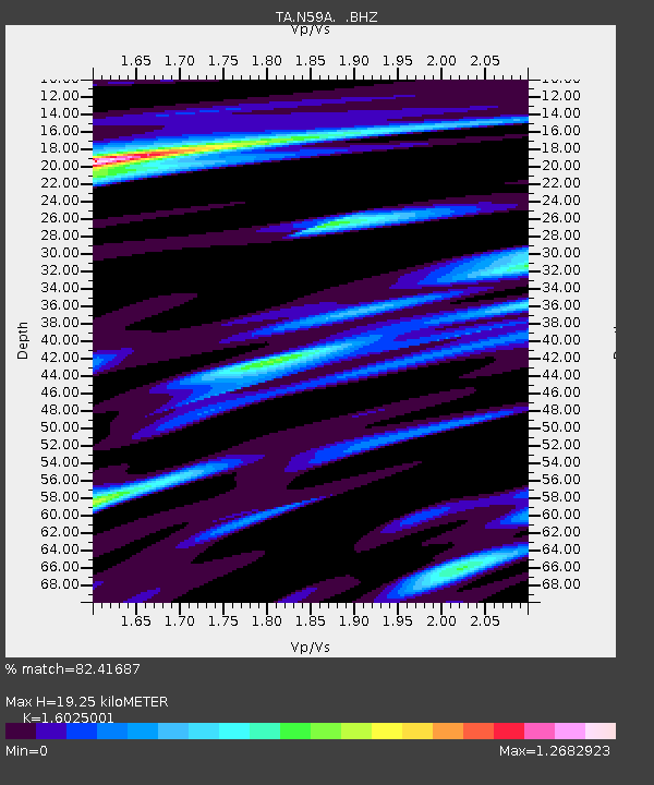
| Estimated Moho Depth: |
19.25 km |
| Estimated Crust Vp/Vs: |
1.60 |
| Assumed Crust Vp: |
6.283 km/s |
| Estimated Crust Vs: |
3.921 km/s |
| Estimated Crust Poisson's Ratio: |
0.18 |
|
| Radial Match: |
82.41687 % |
| Radial Bump: |
400 |
| Transverse Match: |
44.50332 % |
| Transverse Bump: |
400 |
| SOD ConfigId: |
512894 |
| Insert Time: |
2013-09-13 18:04:09.892 +0000 |
| GWidth: |
2.5 |
| Max Bumps: |
400 |
| Tol: |
0.001 |
|
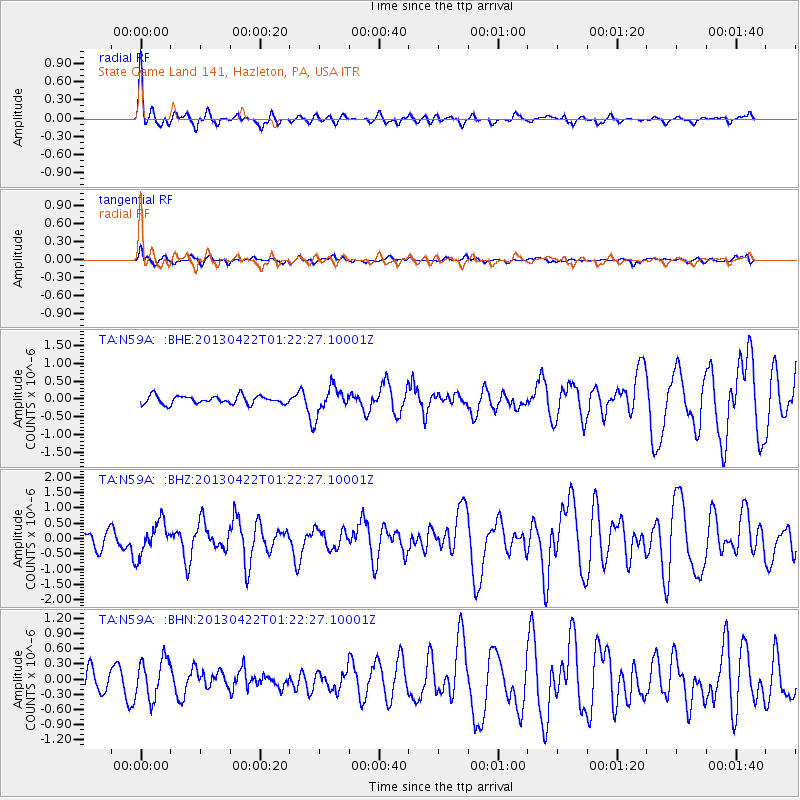
Signal To Noise
| Channel | StoN | STA | LTA |
| TA:N59A: :BHZ:20130422T01:22:27.10001Z | 1.926465 | 5.3181606E-7 | 2.76058E-7 |
| TA:N59A: :BHN:20130422T01:22:27.10001Z | 2.1573489 | 3.8685724E-7 | 1.7932066E-7 |
| TA:N59A: :BHE:20130422T01:22:27.10001Z | 3.2600002 | 3.778833E-7 | 1.1591512E-7 |
| Arrivals |
| Ps | 2.0 SECOND |
| PpPs | 7.3 SECOND |
| PsPs/PpSs | 9.3 SECOND |


