You are here: Home > Network List > US - United States National Seismic Network Stations List
> Station DGMT Dagmar, Montana, USA > Earthquake Result Viewer
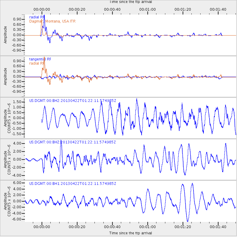
DGMT Dagmar, Montana, USA - Earthquake Result Viewer
*The percent match for this event was below the threshold and hence no stack was calculated.
| Earthquake location: |
Michoacan, Mexico |
| Earthquake latitude/longitude: |
18.1/-102.2 |
| Earthquake time(UTC): |
2013/04/22 (112) 01:16:32 GMT |
| Earthquake Depth: |
30 km |
| Earthquake Magnitude: |
6.0 MW, 5.6 MB, 5.9 MS, 5.9 MW |
| Earthquake Catalog/Contributor: |
NEIC PDE/NEIC PDE-W |
|
| Network: |
US United States National Seismic Network |
| Station: |
DGMT Dagmar, Montana, USA |
| Lat/Lon: |
48.47 N/104.20 W |
| Elevation: |
0.0 m |
|
| Distance: |
30.4 deg |
| Az: |
357.348 deg |
| Baz: |
176.209 deg |
| Ray Param: |
$rayparam |
*The percent match for this event was below the threshold and hence was not used in the summary stack. |
|
| Radial Match: |
90.444725 % |
| Radial Bump: |
239 |
| Transverse Match: |
33.63831 % |
| Transverse Bump: |
348 |
| SOD ConfigId: |
512894 |
| Insert Time: |
2013-09-13 18:04:36.320 +0000 |
| GWidth: |
2.5 |
| Max Bumps: |
400 |
| Tol: |
0.001 |
|
Signal To Noise
| Channel | StoN | STA | LTA |
| US:DGMT:00:BHZ:20130422T01:22:11.574985Z | 6.03999 | 1.3784461E-6 | 2.2821993E-7 |
| US:DGMT:00:BH1:20130422T01:22:11.574985Z | 1.2706026 | 6.779809E-7 | 5.3359E-7 |
| US:DGMT:00:BH2:20130422T01:22:11.574985Z | 1.6601678 | 8.8188654E-7 | 5.312033E-7 |
| Arrivals |
| Ps | |
| PpPs | |
| PsPs/PpSs | |


