You are here: Home > Network List > US - United States National Seismic Network Stations List
> Station HAWA Hanford, Washington, USA > Earthquake Result Viewer
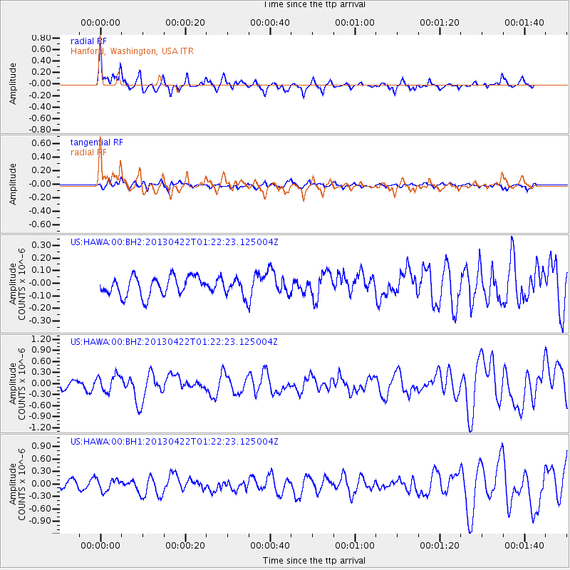
HAWA Hanford, Washington, USA - Earthquake Result Viewer
*The percent match for this event was below the threshold and hence no stack was calculated.
| Earthquake location: |
Michoacan, Mexico |
| Earthquake latitude/longitude: |
18.1/-102.2 |
| Earthquake time(UTC): |
2013/04/22 (112) 01:16:32 GMT |
| Earthquake Depth: |
30 km |
| Earthquake Magnitude: |
6.0 MW, 5.6 MB, 5.9 MS, 5.9 MW |
| Earthquake Catalog/Contributor: |
NEIC PDE/NEIC PDE-W |
|
| Network: |
US United States National Seismic Network |
| Station: |
HAWA Hanford, Washington, USA |
| Lat/Lon: |
46.39 N/119.53 W |
| Elevation: |
364 m |
|
| Distance: |
31.7 deg |
| Az: |
336.851 deg |
| Baz: |
147.297 deg |
| Ray Param: |
$rayparam |
*The percent match for this event was below the threshold and hence was not used in the summary stack. |
|
| Radial Match: |
73.2071 % |
| Radial Bump: |
384 |
| Transverse Match: |
54.189316 % |
| Transverse Bump: |
400 |
| SOD ConfigId: |
512894 |
| Insert Time: |
2013-09-13 18:04:51.984 +0000 |
| GWidth: |
2.5 |
| Max Bumps: |
400 |
| Tol: |
0.001 |
|
Signal To Noise
| Channel | StoN | STA | LTA |
| US:HAWA:00:BHZ:20130422T01:22:23.125004Z | 2.1664536 | 2.2347783E-7 | 1.0315375E-7 |
| US:HAWA:00:BH1:20130422T01:22:23.125004Z | 2.1316543 | 1.3898554E-7 | 6.5200794E-8 |
| US:HAWA:00:BH2:20130422T01:22:23.125004Z | 0.94905466 | 7.145268E-8 | 7.528827E-8 |
| Arrivals |
| Ps | |
| PpPs | |
| PsPs/PpSs | |


