You are here: Home > Network List > PS - Pacific21 Stations List
> Station PSI Parapat, Indonesia > Earthquake Result Viewer
PSI Parapat, Indonesia - Earthquake Result Viewer
| Earthquake location: |
Santa Cruz Islands |
| Earthquake latitude/longitude: |
-10.9/166.0 |
| Earthquake time(UTC): |
1996/09/14 (258) 13:10:53 GMT |
| Earthquake Depth: |
73 km |
| Earthquake Magnitude: |
6.0 MB, 6.0 MS, 6.4 UNKNOWN, 6.4 MW |
| Earthquake Catalog/Contributor: |
WHDF/NEIC |
|
| Network: |
PS Pacific21 |
| Station: |
PSI Parapat, Indonesia |
| Lat/Lon: |
2.69 N/98.92 E |
| Elevation: |
987 m |
|
| Distance: |
68.1 deg |
| Az: |
277.36 deg |
| Baz: |
102.778 deg |
| Ray Param: |
0.056376938 |
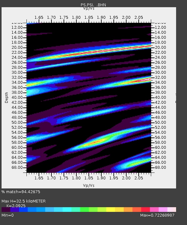
| Estimated Moho Depth: |
32.5 km |
| Estimated Crust Vp/Vs: |
2.09 |
| Assumed Crust Vp: |
6.468 km/s |
| Estimated Crust Vs: |
3.091 km/s |
| Estimated Crust Poisson's Ratio: |
0.35 |
|
| Radial Match: |
94.42675 % |
| Radial Bump: |
400 |
| Transverse Match: |
88.20605 % |
| Transverse Bump: |
400 |
| SOD ConfigId: |
6273 |
| Insert Time: |
2010-02-27 03:19:19.569 +0000 |
| GWidth: |
2.5 |
| Max Bumps: |
400 |
| Tol: |
0.001 |
|
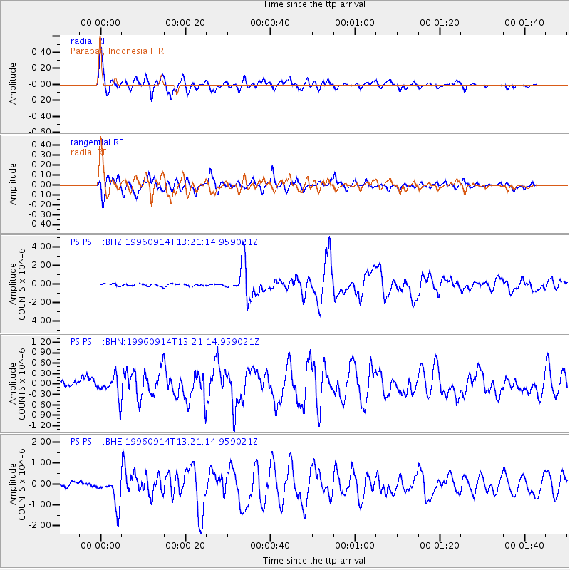
Signal To Noise
| Channel | StoN | STA | LTA |
| PS:PSI: :BHN:19960914T13:21:14.959021Z | 1.8472987 | 3.1212227E-7 | 1.6896145E-7 |
| PS:PSI: :BHE:19960914T13:21:14.959021Z | 5.6467338 | 6.8980074E-7 | 1.2215924E-7 |
| PS:PSI: :BHZ:19960914T13:21:14.959021Z | 15.960106 | 1.8796992E-6 | 1.1777486E-7 |
| Arrivals |
| Ps | 5.7 SECOND |
| PpPs | 15 SECOND |
| PsPs/PpSs | 21 SECOND |


