You are here: Home > Network List > TA - USArray Transportable Network (new EarthScope stations) Stations List
> Station H38A Maiden Rock, WI, USA > Earthquake Result Viewer
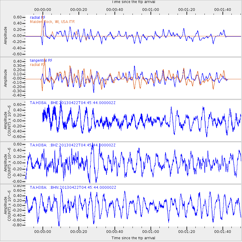
H38A Maiden Rock, WI, USA - Earthquake Result Viewer
*The percent match for this event was below the threshold and hence no stack was calculated.
| Earthquake location: |
Rat Islands, Aleutian Islands |
| Earthquake latitude/longitude: |
51.1/179.4 |
| Earthquake time(UTC): |
2013/04/22 (112) 04:36:36 GMT |
| Earthquake Depth: |
18 km |
| Earthquake Magnitude: |
5.6 MW, 5.5 MW |
| Earthquake Catalog/Contributor: |
NEIC PDE/NEIC PDE-W |
|
| Network: |
TA USArray Transportable Network (new EarthScope stations) |
| Station: |
H38A Maiden Rock, WI, USA |
| Lat/Lon: |
44.68 N/92.28 W |
| Elevation: |
333 m |
|
| Distance: |
56.2 deg |
| Az: |
59.169 deg |
| Baz: |
310.633 deg |
| Ray Param: |
$rayparam |
*The percent match for this event was below the threshold and hence was not used in the summary stack. |
|
| Radial Match: |
54.947315 % |
| Radial Bump: |
400 |
| Transverse Match: |
45.7229 % |
| Transverse Bump: |
400 |
| SOD ConfigId: |
512894 |
| Insert Time: |
2013-09-13 18:28:03.953 +0000 |
| GWidth: |
2.5 |
| Max Bumps: |
400 |
| Tol: |
0.001 |
|
Signal To Noise
| Channel | StoN | STA | LTA |
| TA:H38A: :BHZ:20130422T04:45:44.000002Z | 0.7966823 | 2.1082121E-7 | 2.6462396E-7 |
| TA:H38A: :BHN:20130422T04:45:44.000002Z | 1.4813176 | 2.6864458E-7 | 1.8135516E-7 |
| TA:H38A: :BHE:20130422T04:45:44.000002Z | 0.68679047 | 1.8854823E-7 | 2.7453532E-7 |
| Arrivals |
| Ps | |
| PpPs | |
| PsPs/PpSs | |


