You are here: Home > Network List > TA - USArray Transportable Network (new EarthScope stations) Stations List
> Station I41A Arkdale, WI, USA > Earthquake Result Viewer
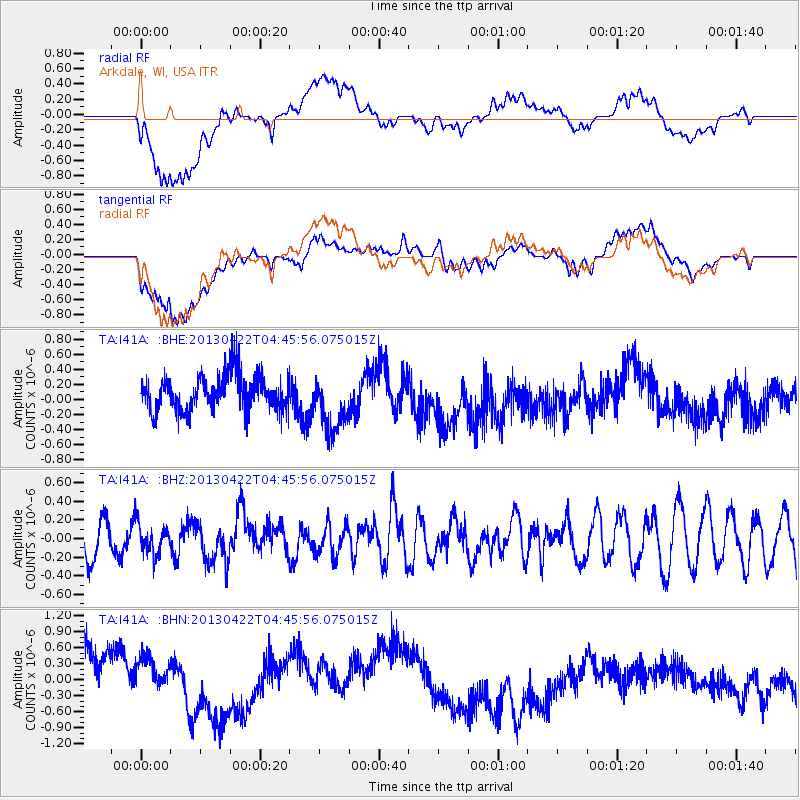
I41A Arkdale, WI, USA - Earthquake Result Viewer
*The percent match for this event was below the threshold and hence no stack was calculated.
| Earthquake location: |
Rat Islands, Aleutian Islands |
| Earthquake latitude/longitude: |
51.1/179.4 |
| Earthquake time(UTC): |
2013/04/22 (112) 04:36:36 GMT |
| Earthquake Depth: |
18 km |
| Earthquake Magnitude: |
5.6 MW, 5.5 MW |
| Earthquake Catalog/Contributor: |
NEIC PDE/NEIC PDE-W |
|
| Network: |
TA USArray Transportable Network (new EarthScope stations) |
| Station: |
I41A Arkdale, WI, USA |
| Lat/Lon: |
44.06 N/89.87 W |
| Elevation: |
289 m |
|
| Distance: |
57.9 deg |
| Az: |
58.361 deg |
| Baz: |
311.874 deg |
| Ray Param: |
$rayparam |
*The percent match for this event was below the threshold and hence was not used in the summary stack. |
|
| Radial Match: |
38.6997 % |
| Radial Bump: |
400 |
| Transverse Match: |
30.114893 % |
| Transverse Bump: |
400 |
| SOD ConfigId: |
512894 |
| Insert Time: |
2013-09-13 18:28:33.308 +0000 |
| GWidth: |
2.5 |
| Max Bumps: |
400 |
| Tol: |
0.001 |
|
Signal To Noise
| Channel | StoN | STA | LTA |
| TA:I41A: :BHZ:20130422T04:45:56.075015Z | 0.7773361 | 1.6165971E-7 | 2.0796631E-7 |
| TA:I41A: :BHN:20130422T04:45:56.075015Z | 0.78045243 | 6.37606E-7 | 8.169697E-7 |
| TA:I41A: :BHE:20130422T04:45:56.075015Z | 1.5836849 | 3.7881273E-7 | 2.3919702E-7 |
| Arrivals |
| Ps | |
| PpPs | |
| PsPs/PpSs | |


