You are here: Home > Network List > PS - Pacific21 Stations List
> Station PSI Parapat, Indonesia > Earthquake Result Viewer
PSI Parapat, Indonesia - Earthquake Result Viewer
| Earthquake location: |
Irian Jaya, Indonesia |
| Earthquake latitude/longitude: |
-2.2/138.9 |
| Earthquake time(UTC): |
1996/12/26 (361) 20:48:23 GMT |
| Earthquake Depth: |
33 km |
| Earthquake Magnitude: |
6.0 MB, 6.1 MS, 6.3 UNKNOWN, 6.1 MW |
| Earthquake Catalog/Contributor: |
WHDF/NEIC |
|
| Network: |
PS Pacific21 |
| Station: |
PSI Parapat, Indonesia |
| Lat/Lon: |
2.69 N/98.92 E |
| Elevation: |
987 m |
|
| Distance: |
40.3 deg |
| Az: |
276.775 deg |
| Baz: |
96.609 deg |
| Ray Param: |
0.074418485 |
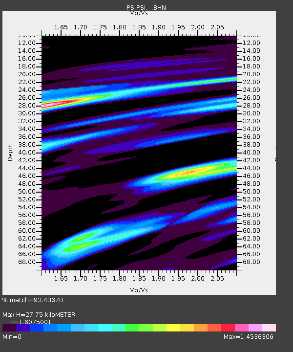
| Estimated Moho Depth: |
27.75 km |
| Estimated Crust Vp/Vs: |
1.61 |
| Assumed Crust Vp: |
6.468 km/s |
| Estimated Crust Vs: |
4.023 km/s |
| Estimated Crust Poisson's Ratio: |
0.18 |
|
| Radial Match: |
93.43678 % |
| Radial Bump: |
400 |
| Transverse Match: |
89.60314 % |
| Transverse Bump: |
398 |
| SOD ConfigId: |
6273 |
| Insert Time: |
2010-02-27 03:19:29.778 +0000 |
| GWidth: |
2.5 |
| Max Bumps: |
400 |
| Tol: |
0.001 |
|
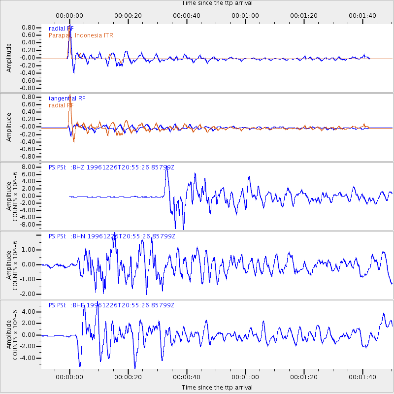
Signal To Noise
| Channel | StoN | STA | LTA |
| PS:PSI: :BHN:19961226T20:55:26.85799Z | 4.4487634 | 3.334983E-7 | 7.496427E-8 |
| PS:PSI: :BHE:19961226T20:55:26.85799Z | 37.65636 | 2.2602133E-6 | 6.002208E-8 |
| PS:PSI: :BHZ:19961226T20:55:26.85799Z | 54.506905 | 3.345241E-6 | 6.1372795E-8 |
| Arrivals |
| Ps | 2.8 SECOND |
| PpPs | 10 SECOND |
| PsPs/PpSs | 13 SECOND |


