You are here: Home > Network List > TA - USArray Transportable Network (new EarthScope stations) Stations List
> Station X46A Booneville, MS, USA > Earthquake Result Viewer
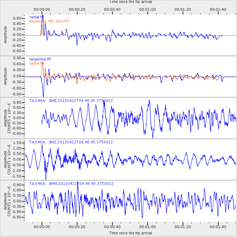
X46A Booneville, MS, USA - Earthquake Result Viewer
*The percent match for this event was below the threshold and hence no stack was calculated.
| Earthquake location: |
Rat Islands, Aleutian Islands |
| Earthquake latitude/longitude: |
51.1/179.4 |
| Earthquake time(UTC): |
2013/04/22 (112) 04:36:36 GMT |
| Earthquake Depth: |
18 km |
| Earthquake Magnitude: |
5.6 MW, 5.5 MW |
| Earthquake Catalog/Contributor: |
NEIC PDE/NEIC PDE-W |
|
| Network: |
TA USArray Transportable Network (new EarthScope stations) |
| Station: |
X46A Booneville, MS, USA |
| Lat/Lon: |
34.56 N/88.58 W |
| Elevation: |
150 m |
|
| Distance: |
65.2 deg |
| Az: |
65.342 deg |
| Baz: |
316.027 deg |
| Ray Param: |
$rayparam |
*The percent match for this event was below the threshold and hence was not used in the summary stack. |
|
| Radial Match: |
56.34423 % |
| Radial Bump: |
400 |
| Transverse Match: |
75.17334 % |
| Transverse Bump: |
400 |
| SOD ConfigId: |
512894 |
| Insert Time: |
2013-09-13 18:34:16.438 +0000 |
| GWidth: |
2.5 |
| Max Bumps: |
400 |
| Tol: |
0.001 |
|
Signal To Noise
| Channel | StoN | STA | LTA |
| TA:X46A: :BHZ:20130422T04:46:45.375002Z | 3.2847025 | 7.525116E-7 | 2.2909583E-7 |
| TA:X46A: :BHN:20130422T04:46:45.375002Z | 0.94070953 | 2.5447892E-7 | 2.7051806E-7 |
| TA:X46A: :BHE:20130422T04:46:45.375002Z | 1.5114515 | 4.3728843E-7 | 2.8931692E-7 |
| Arrivals |
| Ps | |
| PpPs | |
| PsPs/PpSs | |


