You are here: Home > Network List > PS - Pacific21 Stations List
> Station PSI Parapat, Indonesia > Earthquake Result Viewer
PSI Parapat, Indonesia - Earthquake Result Viewer

| Earthquake location: |
Vanuatu Islands |
| Earthquake latitude/longitude: |
-13.6/166.4 |
| Earthquake time(UTC): |
1997/04/23 (113) 03:47:18 GMT |
| Earthquake Depth: |
33 km |
| Earthquake Magnitude: |
5.5 MB, 6.0 MS, 6.1 UNKNOWN, 5.9 MW |
| Earthquake Catalog/Contributor: |
WHDF/NEIC |
|
| Network: |
PS Pacific21 |
| Station: |
PSI Parapat, Indonesia |
| Lat/Lon: |
2.69 N/98.92 E |
| Elevation: |
987 m |
|
| Distance: |
68.8 deg |
| Az: |
278.314 deg |
| Baz: |
105.602 deg |
| Ray Param: |
0.056003757 |
| Estimated Moho Depth: |
20.0 km |
| Estimated Crust Vp/Vs: |
2.04 |
| Assumed Crust Vp: |
6.468 km/s |
| Estimated Crust Vs: |
3.167 km/s |
| Estimated Crust Poisson's Ratio: |
0.34 |
|
| Radial Match: |
95.093735 % |
| Radial Bump: |
400 |
| Transverse Match: |
90.78601 % |
| Transverse Bump: |
400 |
| SOD ConfigId: |
6273 |
| Insert Time: |
2010-02-27 03:19:46.408 +0000 |
| GWidth: |
2.5 |
| Max Bumps: |
400 |
| Tol: |
0.001 |
|
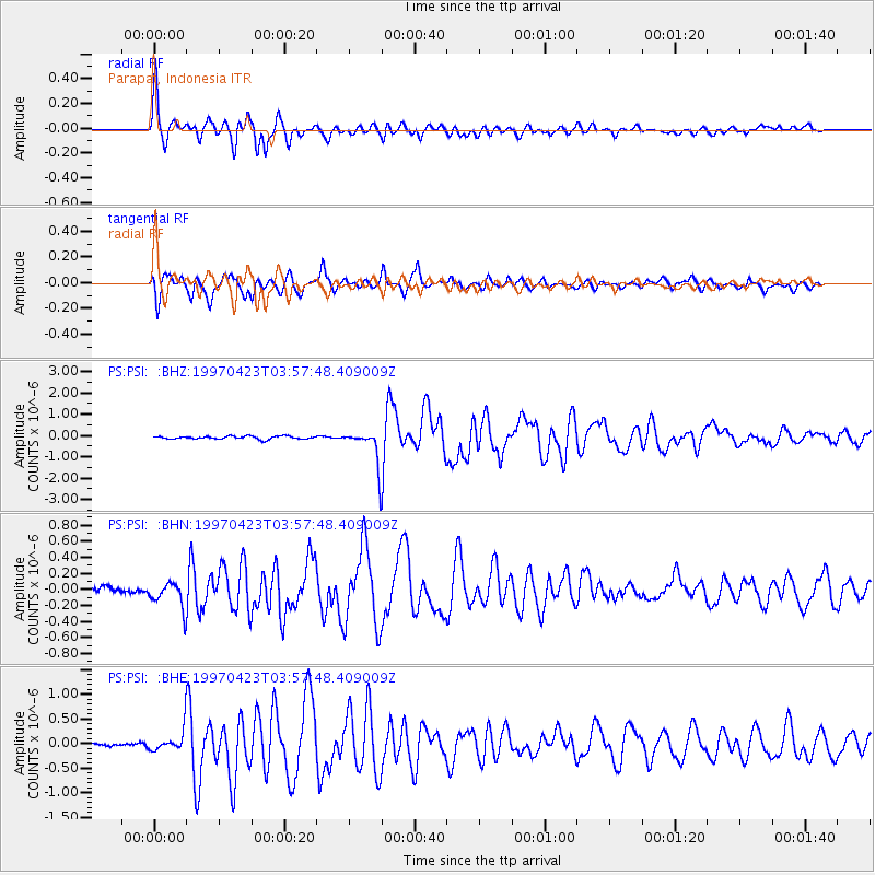
Signal To Noise
| Channel | StoN | STA | LTA |
| PS:PSI: :BHN:19970423T03:57:48.409009Z | 3.080808 | 1.8530804E-7 | 6.014917E-8 |
| PS:PSI: :BHE:19970423T03:57:48.409009Z | 3.043613 | 2.0845685E-7 | 6.848994E-8 |
| PS:PSI: :BHZ:19970423T03:57:48.409009Z | 11.3415985 | 8.220096E-7 | 7.2477405E-8 |
| Arrivals |
| Ps | 3.3 SECOND |
| PpPs | 9.1 SECOND |
| PsPs/PpSs | 12 SECOND |


