You are here: Home > Network List > TA - USArray Transportable Network (new EarthScope stations) Stations List
> Station H17A Grant Village (NPS), Yellowstone Nt. Park, WY, USA > Earthquake Result Viewer
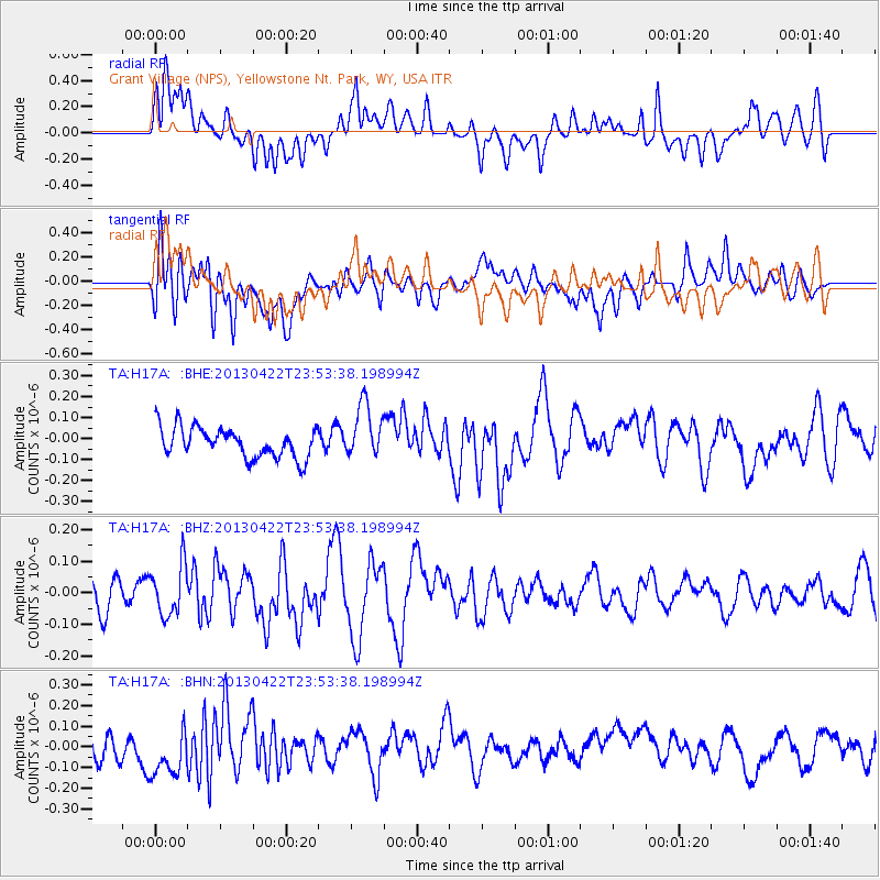
H17A Grant Village (NPS), Yellowstone Nt. Park, WY, USA - Earthquake Result Viewer
*The percent match for this event was below the threshold and hence no stack was calculated.
| Earthquake location: |
Kermadec Islands Region |
| Earthquake latitude/longitude: |
-29.8/-176.2 |
| Earthquake time(UTC): |
2013/04/22 (112) 23:40:47 GMT |
| Earthquake Depth: |
13 km |
| Earthquake Magnitude: |
5.5 MB |
| Earthquake Catalog/Contributor: |
NEIC PDE/NEIC PDE-W |
|
| Network: |
TA USArray Transportable Network (new EarthScope stations) |
| Station: |
H17A Grant Village (NPS), Yellowstone Nt. Park, WY, USA |
| Lat/Lon: |
44.40 N/110.58 W |
| Elevation: |
2400 m |
|
| Distance: |
95.0 deg |
| Az: |
40.97 deg |
| Baz: |
232.663 deg |
| Ray Param: |
$rayparam |
*The percent match for this event was below the threshold and hence was not used in the summary stack. |
|
| Radial Match: |
53.82903 % |
| Radial Bump: |
400 |
| Transverse Match: |
56.556015 % |
| Transverse Bump: |
400 |
| SOD ConfigId: |
512894 |
| Insert Time: |
2013-09-13 18:54:29.249 +0000 |
| GWidth: |
2.5 |
| Max Bumps: |
400 |
| Tol: |
0.001 |
|
Signal To Noise
| Channel | StoN | STA | LTA |
| TA:H17A: :BHZ:20130422T23:53:38.198994Z | 1.375982 | 7.986975E-8 | 5.804563E-8 |
| TA:H17A: :BHN:20130422T23:53:38.198994Z | 1.7926176 | 1.300784E-7 | 7.256339E-8 |
| TA:H17A: :BHE:20130422T23:53:38.198994Z | 1.819221 | 1.2969797E-7 | 7.129313E-8 |
| Arrivals |
| Ps | |
| PpPs | |
| PsPs/PpSs | |


