You are here: Home > Network List > TA - USArray Transportable Network (new EarthScope stations) Stations List
> Station O03E Paynes Creek, CA, USA > Earthquake Result Viewer
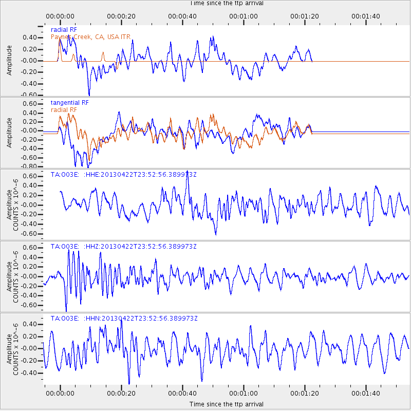
O03E Paynes Creek, CA, USA - Earthquake Result Viewer
*The percent match for this event was below the threshold and hence no stack was calculated.
| Earthquake location: |
Kermadec Islands Region |
| Earthquake latitude/longitude: |
-29.8/-176.2 |
| Earthquake time(UTC): |
2013/04/22 (112) 23:40:47 GMT |
| Earthquake Depth: |
13 km |
| Earthquake Magnitude: |
5.5 MB |
| Earthquake Catalog/Contributor: |
NEIC PDE/NEIC PDE-W |
|
| Network: |
TA USArray Transportable Network (new EarthScope stations) |
| Station: |
O03E Paynes Creek, CA, USA |
| Lat/Lon: |
40.29 N/121.80 W |
| Elevation: |
967 m |
|
| Distance: |
86.1 deg |
| Az: |
38.58 deg |
| Baz: |
225.134 deg |
| Ray Param: |
$rayparam |
*The percent match for this event was below the threshold and hence was not used in the summary stack. |
|
| Radial Match: |
52.371212 % |
| Radial Bump: |
400 |
| Transverse Match: |
56.514206 % |
| Transverse Bump: |
400 |
| SOD ConfigId: |
512894 |
| Insert Time: |
2013-09-13 18:55:27.067 +0000 |
| GWidth: |
2.5 |
| Max Bumps: |
400 |
| Tol: |
0.001 |
|
Signal To Noise
| Channel | StoN | STA | LTA |
| TA:O03E: :HHZ:20130422T23:52:56.389973Z | 4.5189247 | 3.1722695E-7 | 7.0199654E-8 |
| TA:O03E: :HHN:20130422T23:52:56.389973Z | 1.1479355 | 2.1454134E-7 | 1.8689319E-7 |
| TA:O03E: :HHE:20130422T23:52:56.389973Z | 1.0348479 | 1.7193143E-7 | 1.6614175E-7 |
| Arrivals |
| Ps | |
| PpPs | |
| PsPs/PpSs | |


