You are here: Home > Network List > PS - Pacific21 Stations List
> Station PSI Parapat, Indonesia > Earthquake Result Viewer
PSI Parapat, Indonesia - Earthquake Result Viewer
| Earthquake location: |
South Of Fiji Islands |
| Earthquake latitude/longitude: |
-22.2/-179.5 |
| Earthquake time(UTC): |
1998/05/16 (136) 02:22:03 GMT |
| Earthquake Depth: |
586 km |
| Earthquake Magnitude: |
6.1 MB, 6.8 UNKNOWN |
| Earthquake Catalog/Contributor: |
WHDF/NEIC |
|
| Network: |
PS Pacific21 |
| Station: |
PSI Parapat, Indonesia |
| Lat/Lon: |
2.69 N/98.92 E |
| Elevation: |
987 m |
|
| Distance: |
83.2 deg |
| Az: |
275.688 deg |
| Baz: |
112.628 deg |
| Ray Param: |
0.044607386 |
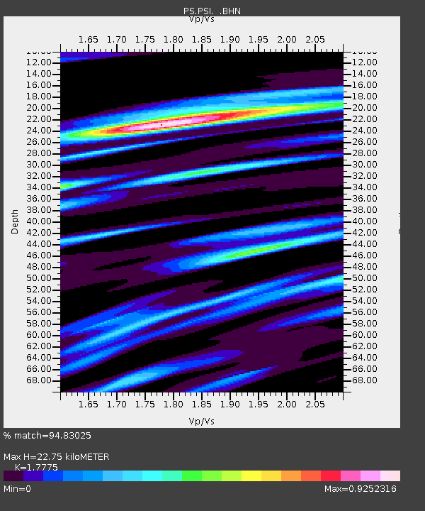
| Estimated Moho Depth: |
22.75 km |
| Estimated Crust Vp/Vs: |
1.78 |
| Assumed Crust Vp: |
6.468 km/s |
| Estimated Crust Vs: |
3.639 km/s |
| Estimated Crust Poisson's Ratio: |
0.27 |
|
| Radial Match: |
94.83025 % |
| Radial Bump: |
400 |
| Transverse Match: |
95.45443 % |
| Transverse Bump: |
400 |
| SOD ConfigId: |
4480 |
| Insert Time: |
2010-02-27 03:20:49.029 +0000 |
| GWidth: |
2.5 |
| Max Bumps: |
400 |
| Tol: |
0.001 |
|
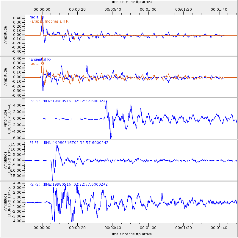
Signal To Noise
| Channel | StoN | STA | LTA |
| PS:PSI: :BHN:19980516T02:32:57.600024Z | 1.7638309 | 1.0667064E-7 | 6.047668E-8 |
| PS:PSI: :BHE:19980516T02:32:57.600024Z | 2.0308924 | 1.04034044E-7 | 5.122578E-8 |
| PS:PSI: :BHZ:19980516T02:32:57.600024Z | 1.1700524 | 8.695977E-8 | 7.432127E-8 |
| Arrivals |
| Ps | 2.8 SECOND |
| PpPs | 9.5 SECOND |
| PsPs/PpSs | 12 SECOND |


