You are here: Home > Network List > TA - USArray Transportable Network (new EarthScope stations) Stations List
> Station G03D McMinnville, OR, USA > Earthquake Result Viewer
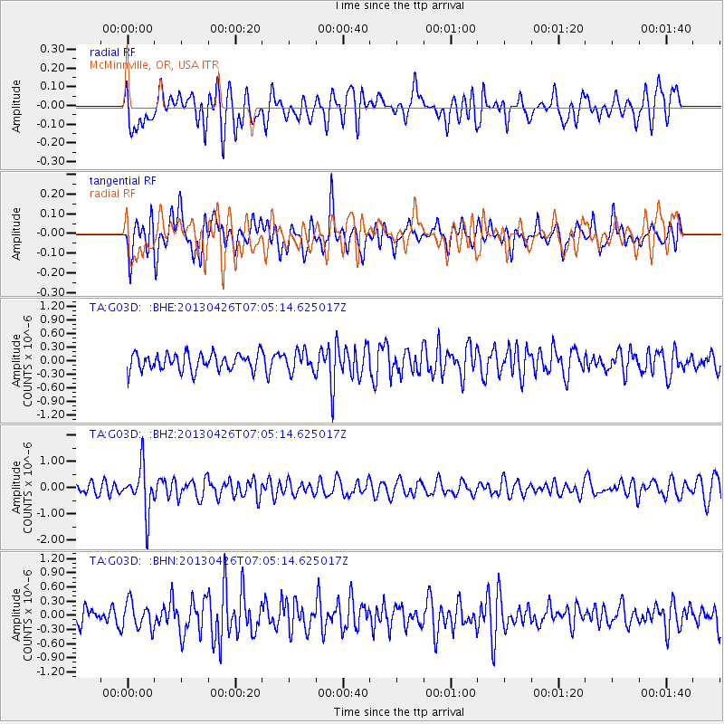
G03D McMinnville, OR, USA - Earthquake Result Viewer
*The percent match for this event was below the threshold and hence no stack was calculated.
| Earthquake location: |
Kermadec Islands Region |
| Earthquake latitude/longitude: |
-28.7/-178.9 |
| Earthquake time(UTC): |
2013/04/26 (116) 06:53:28 GMT |
| Earthquake Depth: |
351 km |
| Earthquake Magnitude: |
6.1 MW, 5.8 MB, 6.2 MW |
| Earthquake Catalog/Contributor: |
NEIC PDE/NEIC PDE-W |
|
| Network: |
TA USArray Transportable Network (new EarthScope stations) |
| Station: |
G03D McMinnville, OR, USA |
| Lat/Lon: |
45.21 N/123.26 W |
| Elevation: |
222 m |
|
| Distance: |
89.3 deg |
| Az: |
35.708 deg |
| Baz: |
226.51 deg |
| Ray Param: |
$rayparam |
*The percent match for this event was below the threshold and hence was not used in the summary stack. |
|
| Radial Match: |
55.734715 % |
| Radial Bump: |
400 |
| Transverse Match: |
55.482933 % |
| Transverse Bump: |
400 |
| SOD ConfigId: |
512894 |
| Insert Time: |
2013-09-13 19:47:53.735 +0000 |
| GWidth: |
2.5 |
| Max Bumps: |
400 |
| Tol: |
0.001 |
|
Signal To Noise
| Channel | StoN | STA | LTA |
| TA:G03D: :BHZ:20130426T07:05:14.625017Z | 3.0748782 | 8.7643826E-7 | 2.8503186E-7 |
| TA:G03D: :BHN:20130426T07:05:14.625017Z | 1.4886945 | 2.8506363E-7 | 1.9148564E-7 |
| TA:G03D: :BHE:20130426T07:05:14.625017Z | 1.2066303 | 2.2545777E-7 | 1.8684908E-7 |
| Arrivals |
| Ps | |
| PpPs | |
| PsPs/PpSs | |


