You are here: Home > Network List > US - United States National Seismic Network Stations List
> Station DUG Dugway, Tooele County, Utah, USA > Earthquake Result Viewer
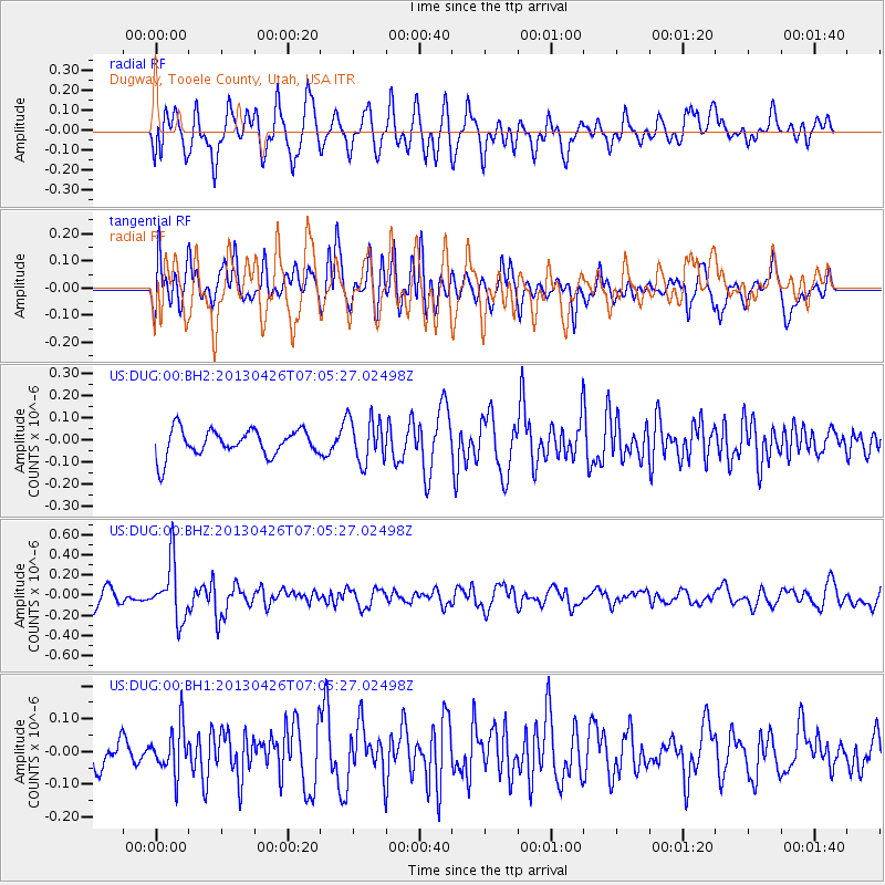
DUG Dugway, Tooele County, Utah, USA - Earthquake Result Viewer
*The percent match for this event was below the threshold and hence no stack was calculated.
| Earthquake location: |
Kermadec Islands Region |
| Earthquake latitude/longitude: |
-28.7/-178.9 |
| Earthquake time(UTC): |
2013/04/26 (116) 06:53:28 GMT |
| Earthquake Depth: |
351 km |
| Earthquake Magnitude: |
6.1 MW, 5.8 MB, 6.2 MW |
| Earthquake Catalog/Contributor: |
NEIC PDE/NEIC PDE-W |
|
| Network: |
US United States National Seismic Network |
| Station: |
DUG Dugway, Tooele County, Utah, USA |
| Lat/Lon: |
40.19 N/112.81 W |
| Elevation: |
1477 m |
|
| Distance: |
92.0 deg |
| Az: |
44.486 deg |
| Baz: |
233.495 deg |
| Ray Param: |
$rayparam |
*The percent match for this event was below the threshold and hence was not used in the summary stack. |
|
| Radial Match: |
60.281593 % |
| Radial Bump: |
400 |
| Transverse Match: |
69.600586 % |
| Transverse Bump: |
400 |
| SOD ConfigId: |
512894 |
| Insert Time: |
2013-09-13 19:50:13.249 +0000 |
| GWidth: |
2.5 |
| Max Bumps: |
400 |
| Tol: |
0.001 |
|
Signal To Noise
| Channel | StoN | STA | LTA |
| US:DUG:00:BHZ:20130426T07:05:27.02498Z | 4.4349985 | 2.817606E-7 | 6.353117E-8 |
| US:DUG:00:BH1:20130426T07:05:27.02498Z | 1.4190118 | 7.0199334E-8 | 4.9470575E-8 |
| US:DUG:00:BH2:20130426T07:05:27.02498Z | 1.6986109 | 1.01194736E-7 | 5.9574997E-8 |
| Arrivals |
| Ps | |
| PpPs | |
| PsPs/PpSs | |


