You are here: Home > Network List > US - United States National Seismic Network Stations List
> Station NEW Newport, Washington, USA > Earthquake Result Viewer
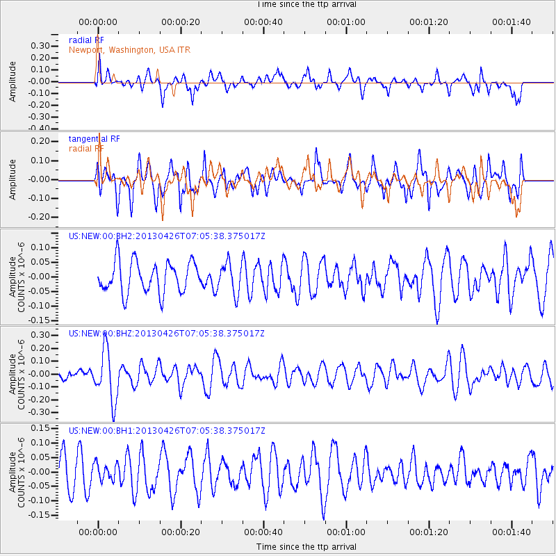
NEW Newport, Washington, USA - Earthquake Result Viewer
*The percent match for this event was below the threshold and hence no stack was calculated.
| Earthquake location: |
Kermadec Islands Region |
| Earthquake latitude/longitude: |
-28.7/-178.9 |
| Earthquake time(UTC): |
2013/04/26 (116) 06:53:28 GMT |
| Earthquake Depth: |
351 km |
| Earthquake Magnitude: |
6.1 MW, 5.8 MB, 6.2 MW |
| Earthquake Catalog/Contributor: |
NEIC PDE/NEIC PDE-W |
|
| Network: |
US United States National Seismic Network |
| Station: |
NEW Newport, Washington, USA |
| Lat/Lon: |
48.26 N/117.12 W |
| Elevation: |
760 m |
|
| Distance: |
94.5 deg |
| Az: |
36.203 deg |
| Baz: |
230.958 deg |
| Ray Param: |
$rayparam |
*The percent match for this event was below the threshold and hence was not used in the summary stack. |
|
| Radial Match: |
50.886005 % |
| Radial Bump: |
400 |
| Transverse Match: |
66.094734 % |
| Transverse Bump: |
400 |
| SOD ConfigId: |
512894 |
| Insert Time: |
2013-09-13 19:50:38.324 +0000 |
| GWidth: |
2.5 |
| Max Bumps: |
400 |
| Tol: |
0.001 |
|
Signal To Noise
| Channel | StoN | STA | LTA |
| US:NEW:00:BHZ:20130426T07:05:38.375017Z | 3.2307065 | 2.0448562E-7 | 6.3294394E-8 |
| US:NEW:00:BH1:20130426T07:05:38.375017Z | 0.3494595 | 2.9446632E-8 | 8.4263355E-8 |
| US:NEW:00:BH2:20130426T07:05:38.375017Z | 1.0023272 | 5.276589E-8 | 5.2643376E-8 |
| Arrivals |
| Ps | |
| PpPs | |
| PsPs/PpSs | |


