You are here: Home > Network List > UW - Pacific Northwest Regional Seismic Network Stations List
> Station MRBL Marblemount, WA, USA > Earthquake Result Viewer
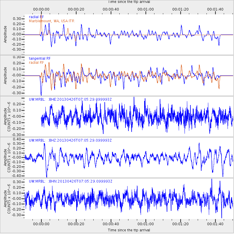
MRBL Marblemount, WA, USA - Earthquake Result Viewer
*The percent match for this event was below the threshold and hence no stack was calculated.
| Earthquake location: |
Kermadec Islands Region |
| Earthquake latitude/longitude: |
-28.7/-178.9 |
| Earthquake time(UTC): |
2013/04/26 (116) 06:53:28 GMT |
| Earthquake Depth: |
351 km |
| Earthquake Magnitude: |
6.1 MW, 5.8 MB, 6.2 MW |
| Earthquake Catalog/Contributor: |
NEIC PDE/NEIC PDE-W |
|
| Network: |
UW Pacific Northwest Regional Seismic Network |
| Station: |
MRBL Marblemount, WA, USA |
| Lat/Lon: |
48.52 N/121.48 W |
| Elevation: |
75 m |
|
| Distance: |
92.4 deg |
| Az: |
34.113 deg |
| Baz: |
227.829 deg |
| Ray Param: |
$rayparam |
*The percent match for this event was below the threshold and hence was not used in the summary stack. |
|
| Radial Match: |
44.165382 % |
| Radial Bump: |
400 |
| Transverse Match: |
62.974396 % |
| Transverse Bump: |
400 |
| SOD ConfigId: |
512894 |
| Insert Time: |
2013-09-13 19:53:07.826 +0000 |
| GWidth: |
2.5 |
| Max Bumps: |
400 |
| Tol: |
0.001 |
|
Signal To Noise
| Channel | StoN | STA | LTA |
| UW:MRBL: :BHZ:20130426T07:05:29.099993Z | 4.620148 | 1.7993325E-7 | 3.8945345E-8 |
| UW:MRBL: :BHN:20130426T07:05:29.099993Z | 1.2123317 | 1.002053E-7 | 8.265503E-8 |
| UW:MRBL: :BHE:20130426T07:05:29.099993Z | 0.94340456 | 8.355716E-8 | 8.856981E-8 |
| Arrivals |
| Ps | |
| PpPs | |
| PsPs/PpSs | |


