You are here: Home > Network List > TA - USArray Transportable Network (new EarthScope stations) Stations List
> Station K39A Oelwein, IA, USA > Earthquake Result Viewer
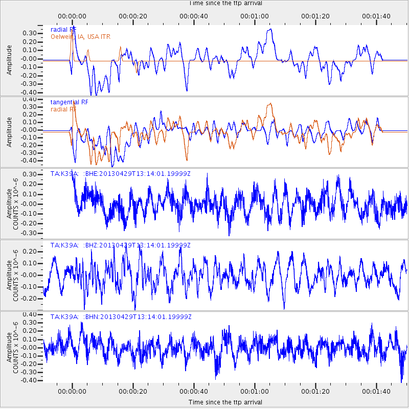
K39A Oelwein, IA, USA - Earthquake Result Viewer
*The percent match for this event was below the threshold and hence no stack was calculated.
| Earthquake location: |
Near East Coast Of Honshu, Japan |
| Earthquake latitude/longitude: |
35.7/141.0 |
| Earthquake time(UTC): |
2013/04/29 (119) 13:01:44 GMT |
| Earthquake Depth: |
35 km |
| Earthquake Magnitude: |
5.6 MW, 5.5 MW |
| Earthquake Catalog/Contributor: |
NEIC PDE/NEIC PDE-W |
|
| Network: |
TA USArray Transportable Network (new EarthScope stations) |
| Station: |
K39A Oelwein, IA, USA |
| Lat/Lon: |
42.71 N/91.89 W |
| Elevation: |
332 m |
|
| Distance: |
88.3 deg |
| Az: |
36.01 deg |
| Baz: |
319.52 deg |
| Ray Param: |
$rayparam |
*The percent match for this event was below the threshold and hence was not used in the summary stack. |
|
| Radial Match: |
44.419582 % |
| Radial Bump: |
400 |
| Transverse Match: |
55.227943 % |
| Transverse Bump: |
400 |
| SOD ConfigId: |
512894 |
| Insert Time: |
2013-09-13 20:18:38.534 +0000 |
| GWidth: |
2.5 |
| Max Bumps: |
400 |
| Tol: |
0.001 |
|
Signal To Noise
| Channel | StoN | STA | LTA |
| TA:K39A: :BHZ:20130429T13:14:01.19999Z | 1.0133693 | 9.167634E-8 | 9.046686E-8 |
| TA:K39A: :BHN:20130429T13:14:01.19999Z | 1.7948362 | 1.889595E-7 | 1.05279526E-7 |
| TA:K39A: :BHE:20130429T13:14:01.19999Z | 0.8010466 | 9.061659E-8 | 1.1312274E-7 |
| Arrivals |
| Ps | |
| PpPs | |
| PsPs/PpSs | |


