You are here: Home > Network List > TA - USArray Transportable Network (new EarthScope stations) Stations List
> Station L39A Vinton, IA, USA > Earthquake Result Viewer
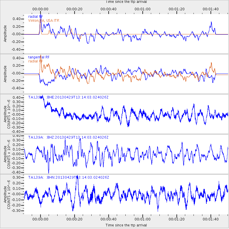
L39A Vinton, IA, USA - Earthquake Result Viewer
*The percent match for this event was below the threshold and hence no stack was calculated.
| Earthquake location: |
Near East Coast Of Honshu, Japan |
| Earthquake latitude/longitude: |
35.7/141.0 |
| Earthquake time(UTC): |
2013/04/29 (119) 13:01:44 GMT |
| Earthquake Depth: |
35 km |
| Earthquake Magnitude: |
5.6 MW, 5.5 MW |
| Earthquake Catalog/Contributor: |
NEIC PDE/NEIC PDE-W |
|
| Network: |
TA USArray Transportable Network (new EarthScope stations) |
| Station: |
L39A Vinton, IA, USA |
| Lat/Lon: |
42.12 N/92.00 W |
| Elevation: |
261 m |
|
| Distance: |
88.6 deg |
| Az: |
36.452 deg |
| Baz: |
319.456 deg |
| Ray Param: |
$rayparam |
*The percent match for this event was below the threshold and hence was not used in the summary stack. |
|
| Radial Match: |
43.73632 % |
| Radial Bump: |
400 |
| Transverse Match: |
22.392563 % |
| Transverse Bump: |
400 |
| SOD ConfigId: |
512894 |
| Insert Time: |
2013-09-13 20:19:06.245 +0000 |
| GWidth: |
2.5 |
| Max Bumps: |
400 |
| Tol: |
0.001 |
|
Signal To Noise
| Channel | StoN | STA | LTA |
| TA:L39A: :BHZ:20130429T13:14:03.024026Z | 1.571863 | 1.2479926E-7 | 7.9395754E-8 |
| TA:L39A: :BHN:20130429T13:14:03.024026Z | 1.171882 | 1.033363E-7 | 8.817978E-8 |
| TA:L39A: :BHE:20130429T13:14:03.024026Z | 0.9522492 | 1.3922256E-7 | 1.4620392E-7 |
| Arrivals |
| Ps | |
| PpPs | |
| PsPs/PpSs | |


